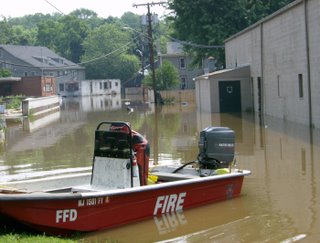
Wally Jenness of Holland Township sent the above pic of the Frenchtown post office (left background). This section of town was flooded by the backed up tributary, a scenario that occurs in many river towns.
A visit to the main gauges around the Delaware River Basin indicates that the storms that swept through the region yesterday afternoon had no impact on stream flow. Speaking of rain, go to the Delaware River Basin Summary of June 2006 Flooding page and click on "View National Weather Service Precipitation Maps." The first map colorfully tells the story of the origins of this flood.
The river at Riegelsville continues to fall and is now around 14.66' or about 7 feet below flood stage. A chance of thunderstorms exists today and Tuesday, with showers for Wednesday as a REAL cold front moves in bringing what just may be an extended dry period. That would give enough time for the river and its tribs to fall to more normal levels.
Yesterday we visited Stockton, NJ and found conditions there are similar to April '05. The most vulnerable properties in the flood plain were hit again (Mill Street and Brookville). Today we are heading upriver to visit friends along Cooks Creek, a sweet tributary that joins the Delaware River just below Riegelsville.


1 comment:
As a former Pennsylvanian who now knows someone "on the river," I have found your blog fascinating reading. Of course, I am viewing this from 3000 miles away (Pasadena, CA) and, if closer, I would use a term such as "useful" or "well-informed" and find the information you share valuable in understanding the dynamics of my neighborhood. The pollution you now face in the Delaware River sounds like it is of frightening proportions and I will be interested in hearing how it is dealt with and how long it is before the river flushes out the garbage it has taken on in the past week.
Thanks,John!
Nancy
Post a Comment