Monday, November 27, 2006

Four hours on the Musconetcong...


That's what Eric, Wally and I did today, and that includes a leisurely lunch by Penwell Mill.

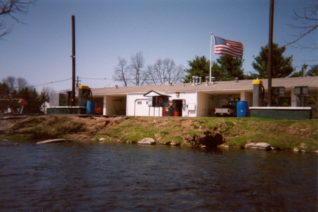
The above pics: Wally and Eric (kayak) pose in front of the Kings Highway Bridge. Much improved over the previous structure in every way. Pic #2 is the Pollution farm alluded to in the previous post. It is the single greatest source of pollution to the Musconetcong River. I'd rather see a housing development any day.

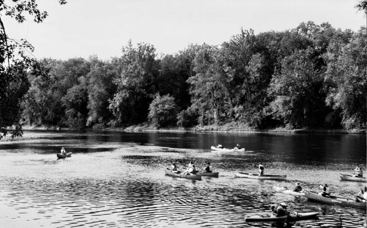
Beattystown to Hampton is about 12 miles of mostly swift current. Swiftly moving stream is reputedly what the Lenape called this river. It was running around 2.64' at Bloomsbury, and that is a perfect level.

This is such a fun stretch of water, it moves right along, but easy class one moving water allows for lots of sightseeing and there is so much to see -- natural and cultural beauty in abundance.

Sunday, November 26, 2006

Another Musconetcong Monday?


The pic, entitled "Just Me and My Pygmy Pony, Over By the Dental Floss Bush" was taken by Sharon on Veterans Day 2005, a 75 deg. Indian Summer escapade to Assateague Island National Seashore, one of my favorite camping and R&R destinations.

Last Monday the Musky was at 2.60', an ideal level. But the "real feel" temperature was around 35 deg. I found reasons to not paddle. It was windy, cloudy and cold, and the REAL JOB necessitates doing certain things on my DAY OFF. So what if I never even break 400 miles, at least 100 miles short of my goal for 2006. It's possible I'll reach 400 mi. but not at all likely. That's sad. I know some folks who regularly do over 1000 mi. per year.

But it's not the quantity that counts, in the end. Thing is all my miles are quality and the miles represent TIME ON THE WATER.

Tomorrow it will be a balmy 63 deg. and I will be paddling the Musconetcong River between Kings Highway Bridge in Beattystown and Hampton Borough Park, about 12 miles of varied scenery including mixed hemlock/hardwood, a bit of class 2 water, Point Mountain, lime kilns, farms, national historic register
hamlets (Beattystown and New Hampton) and structures (Pony Truss Bridge), and the ugliest farm in northern New Jersey, a virtual pollution factory of geese and steers. This is one farm I'd glady see converted to a cul-de-sac McMansion slum.

I'll be joined by Eric and Wally (a hopeful).

I haven't paddled this stretch for perhaps 3 years, before the Kings Hgwy bridge was replaced. I'll have a pic or two if the disposable camera doesn't take a swim.

Thursday, November 23, 2006

Rivers rising...

This storm is hanging around a little longer than expected. The Lehigh River, Brodhead Creek, Musconetcong River and Tohickon are all on the rise. The Delaware River will come up several feet but still not come close to flood stage, if it clears out tonight as predicted.

Nice Nor'easter...

Thappy Hanksgiving!


As Nor'easters go this one wasn't so bad. The Delaware River is just beginning to rise from 8' at Riegelsville and probably won't go up more than 3 or 4' by Sunday. The Musconetcong River stayed at a steady 2.60' all week and now has surged to 3' and rising. Discharge from Lake Hopatcong will keep it high enough for paddling.

We have several days of nice weather on tap, but according to AccuWeather a deep freezer full of Arctic air will pour down on us later next week; really really cold air.

Tuesday, November 21, 2006

Another nor'easter coming...

Let's watch this for potential impacts on streams and rivers large and small. It's a big question mark in terms of rainfall totals.

The Delaware River at Riegelsville has fallen back down to 9.34' which is a good thing. The ground is still staurated and that is not good.

Thursday, November 16, 2006

Eye-popping storm...

...for the upper Schuylkill River Basin that is. I just stumbled across the Tulpehocken Creek, a Schuylkill trib that runs into the river at Reading, PA. The creek at Bernville has so far risen from 2' to almost 8' today. According to the USGS the record is about 9.5 feet, set during Hurricane Agnes in 1972. Looks like it will surpass that tonight.

A floodwatch is in effect for Berks and Montgomery counties, which might as well be code for Schuylkill River Basin.

Go figure. I start a real job and am now blogging more frequently. Crazy weather makes me do it.

Big blow...


ABOVE: Republican for dinner

It isn't over yet but few stations are getting more than an inch of rain. The upper Schuylkill River watershed in Schuylkill County is an exception, some folks there have been pounded by nearly 4 inches of rain.

The streams and rivers are just now beginning to rise.

Let's hope we can dry out for a few days before the next storm. Eventually the jet stream will shift from the Pacific Ocean to the Arctic.

Wednesday, November 15, 2006

Not a nor'easter but...


The Delaware River at Riegelsville is pictured above, captured by Sharon Maclean (my love) at the start of the September 2005 Project River Bright. I am out in front waiting for the NJ Youth Corps members to catch up.


This impending storm is coming from the southwest and may bring up to 2" inches rain and more wherever thunderstorms occur. The action will begin after noon tomorrow.

The Delaware River at Riegelsville is at 7.05' and will likely rise up to twice that level depending on what falls in the upper watersheds, but that would still be a long way from flood stage, which is 22'.

Not surprisingly, most of the upper tribs on both sides of the Delaware are running higher than normal.

I don't believe there will be enough precipitation to pose a flood threat for the larger rivers, but some small flashy streams could rise out of their banks. Let's hope the predictions are relatively accurate. Most of the rain is supposed to fall well to the west.

Tuesday, November 14, 2006

Monday on the Musconetcong...

Good thing I have friends who can get out of work at a moments notice, like Eric Sween did today. He made it possible to paddle the Musconetcong on my day off from the vineyard. The river never did eclipse 2.50' so I bailed on doing the Saxton Falls section. It's just a little too bony for me at that level, specially with that soft spot underneath the Howler.

We met at the takeout near Bloomsbury, just downstream from I-78. Put-in at Hampton Borough park. 2.50 is an ideal level for this stretch of the river. Saw a few black duck, great blues, kingfishers, and other wise uneventful but very peaceful run. Balm for the soul.

Monday, November 13, 2006

A wimpy nor'easter...


Not much in the way of rainfall, but lot's of leaves fell.

The Musconetcong River, pictured above at the car wash below Hackettstown, has actually gone down slightly (it's at 2.46' right now), which is a bummer. 'Twas hoping to paddle the whitewater section below Saxton Falls and that is more enjoyable when the river at Bloomsbury is above 2.50 and preferably closer to 3.00. It doesn't look promising for that stretch.

Tuesday is a day off and warm temps - must get on a river!

-- "He who hears the rippling of rivers in these degenerate days will not utterly despair."
Henry David Thoreau

Saturday, November 11, 2006

What kind of autumn do we have here?...

I shot the above photo facing upstream on the Musky between Pt. Mountain bridge and Penwell dam. October 1999. I think this pic illustrates why the Musconetcong River is one of only 3 national Wild and Scenic Rivers entirely within NJ. OK, just a technicality here. It has not been officially designated yet. It's eligible, but the bill languishes in the lameduck Congress. At least it's chief sponsor, a Warren County Republican Congressman was reelected. Ah yes! Warren County - a slice of central Pennsylvania and Alabama right here in Neew Jersey.

Oh, perhaps it's just a temporary pattern of wetter than usual weather, even for typically erratic November standards.

Looks like another 1-2 inches coming our way in the form of the second nor'easter within the past week. The Delaware River is actually falling and at 10:00 PM is around 8'. A few inches more rain over next 18 hours will take the river up to 15 feet or so.

All the tribs are up a little bit and some of the more flood prone piedmont streams might leave their banks. In NJ the Musconetcong at Bloomsbury is at 2.62, a perfect level for paddling. It will surge back up to near bank full and hopefully it will fall back to around 3 feet for a Tuesday trip on the upper river below Saxton Falls. It's a nice boulder chocked Class II section just below the flat and sandy terminal morraine. Anyone want to join us?

Thursday, November 09, 2006

Surging Delaware...


I thought it odd that the Delaware River at Riegelsville gage flatlined yesterday. Must have been a gage glitch. Now it is surging again...heading to 10 ft. and maybe 3 or 4 more feet before it levels off.

We have a few dry days coming up!