Wednesday, March 28, 2007

River still rising...


I captured this sunset at Assateague National Seashore a few years back. Heading down to the ocean and Delaware Bay this weekend, to Cape May and/or Cape Henloppen. Then back home for canoe trips on the Musconetcong River and Flatbrook if the water levels hold.

What gives? The Delaware River at Rieglesville is still rising, now near 13 feet. The river at Belvidere is beginning to flatline, so that is encouraging. With no serious rain in the forecast there isn't much to worry about for now. Flood stage for the Riegelsville gage is 22' and that we will not see, hopefully for many many moons.

The Lackawaxen River and many other streams rose rapidly yesterday in response to the 70 deg. day, and the snow pack is fast disapearing.

The Musconetcong River has crashed dramatically from 2.80' to 2.35' and that was just today. The lower level reflects the end of the last big dump of water from New Jersey's largest lake (Hopatcong).

NYC reservoirs have shot back up to 95% capacity, 10% higher that before the last winter-like spring storm.

The good news is the forecast of mostly sunny skies, breezes and low humidity, conditions needed to melt remaining snow, lower soil moisture, and bring streams and rivers back down to seasonal levels.

Sunday, March 25, 2007

Dwindling Flood threat...


Paddling buddy Arlene looks up from the Upper Tohickon during an '06 April trip.

We are experiencing the perfect melt-down of snow in the river basin and that means a drastically reduced threat of the dreaded SPRING FRESHET, which is a mostly out of use term for the type of flood that results from a rapidly melting snow pack.

The Delaware River at the Belvidere Gage is a few feet higher than normal, but it is still a long way from flood stage. The Lehigh is also running considerably higher than normal for this date, and that is the point: we are having a late snow melt thanks to the late ice and snow storm.

With no heavy rain in sight, it looks like we'll get through one of the most vulnerable times of the year for flooding, without another nasty event. About half the record Delaware River floods have occured during the SPRING FRESHET period; April 2005 was a classic example.

Sadly I missed a Musconetcong River trip today, had a piano gig. For shame as it was running a near perfect 3.00'.

Friday, March 23, 2007

Watch the river...

From AccuWeather...

Yesterday, a cold front swept across the Great Lakes region and into the Midwest with gusty thunderstorms, hail and even three reports of tornadoes. With the lack of a major cold push, this cold front weakened and stalled as it pressed into warm, moist air. The result will be a stationary front from the mid-Atlantic, through the Midwest and into the central Plains. Waves of low pressure along this front will bring bursts of heavy rain and thunderstorms. With this front lingering through the weekend, rainfall totals will begin to reach several inches across a wide area with the prospects of flooding.

Monday, March 19, 2007

FLOODWISE: Where are we now?

The above photo of a beaver chewed tree was shot by Harold Deal on a canoe trip down Beaver Brook, major tributary to the Pequest River, one of NJ's fine limestone trout streams.


There is now an even greater on-the-ground flood potential, thanks to the ice-snow storm. According to the National Weather Service Hydrologic Outlook the piedmont and highlands portion of the Delaware River Basin have between 1-5 inches of frozen precip on the ground. The upper basin has considerably more -- up to 16 inches.

The Delaware River at the Belvidere gage is running a bit higher than normal. The tribs are at or slightly above normal flow, but that will change rapidly when the melt begins again in earnest.

Water equivalents (of the snow and ice) range from 1" in the piedmont to over 5" in the Appalachian Plateau portion of the upper Delaware River watershed. Reservoirs (flood and water supply) are above average capacity, ground is frozen and wet. The only good news is the river ice is no longer a threat.

If we have gentle showers and gradual warming the river and tribs will absorb the runoff. We don't want a heavy rain.

Upper Tohickon rocks...


Met three new paddling partners for a swift ride down the upper Toh on a chilly but sunny Sunday. Roy, Looie and Vin all paddled whitewater canoes, rare to not have any 'yakkers on board. Creek was running around 3.25' at the Pipersville gage.

Vin leads trips for the Mohawk Canoe Club, Roy and Looie are members of the Philly Canoe Club, which is almost as old as Mohawk (1903 vs. 1905).

We observed plenty of wildlife (birds) including mergansers, wood duck, black duck, golden eye (?), phoebes (welcome back!). A flock of bluebirds followed me down the last stretch of the creek, brilliant blue against the white landscape. The Tohickon is noted for its shale bluffs (High Rocks) and the upper creek has smaller but very pretty bluffs with ferns, lichen, and on this trip, many crystal clear ice formations.

Getting in and out of the creek was mightly tricky thanks to the ice encrusted snow, made for slippery exits. We were the only souls out on this stretch of the creek, and I like that.

Thanks to Vin I enjoyed my first taste of moose meat, in the form of "beef sticks." I didn't really feel like opening the can of sardines anyway - thanks Vin.

Friday, March 16, 2007

Flood Potential Update

The Advanced Hydrologic Prediction Service shows the river at Riegelsville topping off around 12.50' (10 feet below flood stage). It is now at 10.30' and surging upward. I think it will surpass the current prediction.

Most upriver streams have already peaked, probably because they are getting snow, and the rising water levels in the upper watershed were occuring because of snow melt.

I don't think there is much to worry about with this storm. But the next rain storm could cause flooding problems due to the increased snow pack in the upper watersheds. The ideal scenario would be for a gradual warming minus rain.

I plan to paddle the Upper Tohickon on Sunday, if anyone cares to join in. It will be quite cold (40 deg.), but with snow on the ground, so very beautiful. The upper Toh is a Class I & II (maybe just a touch of III) creek and with the Nockamixon dam release it is very pushy, only appropriate for experienced paddlers with proper cold weather gear.

Thursday, March 15, 2007

Flood Potential

The NWS has a flood watch in effect for the Delaware River and tribs. Not a warning, a watch. There's a few inches of water tied up in the snow pack in the upper Delaware and Lehigh watersheds and if we get a few inches the river could come up near flood stage. We'll know much more tomorrow morning.

Check the PA/NJ Hydrology link and also the DRBC flood page.

RIVERS AND STREAMS THROUGHOUT THE REGION WILL EXPERIENCE SIGNIFICANT RISES IF THIS EVENT UNFOLDS AS FORECAST. MANY SMALLER STREAMS MAY RISE ABOVE FLOOD STAGE FRIDAY...AND THE MAIN STEM RIVERS...SUCH AS THE LEHIGH AND DELAWARE RIVERS...WILL EXPERIENCE MAJOR RISES AS WELL. AN AGGRAVATING FACTOR FOR ANY FLOODING POTENTIAL ALONG THE LEHIGH AND DELAWARE RIVERS IS THE EXISTING SNOW PACK IN THE UPPER PORTIONS OF BOTH WATERSHEDS. ANYWHERE BETWEEN 2 AND 5 INCHES OF WATER IS STORED IN THAT SNOW PACK...AND

IF IT MELTS FAST ENOUGH AND IN ENOUGH QUANTITY...FLOODING COULD ENSUE ALONG BOTH RIVERS. RESIDENTS ALONG ALL RIVERS AND STREAMS ARE URGED TO MONITOR THE UNFOLDING WEATHER SITUATION AND BE PREPARED TO TAKE APPROPRIATE ACTION SHOULD THE NEED ARISE. THE MAJORITY OF THE RIVERS IN EASTERN PENNSYLVANIA AND NEW JERSEY ARE ICE FREE AT THIS TIME. EVEN THOUGH SOME ICE EXISTS IN THE NEW YORK PORTION OF THE DELAWARE RIVER...THE THREAT OF ICE JAM FLOODING IS MINIMAL AT BEST.

Monday, March 12, 2007

WATERS OF MARCH...


Harold took a shot of the Rivergeek with the City of Easton in background.

Harold Deal floats downstream with camera in hand as I look upstream at the bridges of Easton-Phillipsburg. Note the flood debris caught under the railroad bridge, some 30 feet above the water.


M
et Harold Deal at Riegelsville and we shuttled up to Phillipsburg NJ for a ten mile run through the Highlands section of the river. Passed many limestone tributary rivers and creeks along the way including the Lehigh River, Lopatcong Creek, Pohatcong Creek, Musconetcong River, and Frys Run.

Except for a few shore fishermen, we had the river to ourselves. Well, not really, as there were numerous wood duck, hundreds of Canada Geese (mostly migrants and a few nesting pairs), common mergansers, black duck, unidentified migrating diving ducks, and kingfishers.

It was balm for the soul.

Saturday, March 10, 2007

SPRING HAS SPRUNG

Shad Fisherman below Bulls Island Dam

F
orget daylight saving time, that bizarre social construct first mentioned by Ben Frankin as a satirical suggestion to the French and first implemented by the Kaiser during WWI. Once we set the clock, it's mostly forgotten.

Sure, the Vernal Equinox is two weeks away, but my ears, eyes and nose tell me that spring has arrived, announced by the territorial bird calls, smell of fresh earth, and snow drops blooming in the yard.

We can have a blizzard next week, or two weeks into astronomical spring, that wouldn't change the reality of spring for the titmouse, cardinal or crocus. Spring has sprung.

I plan to paddle the Delaware River on Monday to get a taste of this thing called spring. The river at Riegelsville is back down to a comfortable 4.43' after it's 6-foot spike to over ten feet last week. That's a little below the average daily mean. The NYC reservoir levels haven't changed significantly and are still about 84% capacity.

Meanwhile, this just off the press from the NWS:

NATIONAL WEATHER SERVICE BINGHAMTON NY
FRI MAR 9 2007

NEXT WEEK IS SEVERE WEATHER AWARENESS WEEK IN PENNSYLVANIA...

EACH SPRING BEFORE THE ONSET OF THE THUNDERSTORM AND FLASH FLOOD
SEASON...THE PENNSYLVANIA EMERGENCY MANAGEMENT AGENCY...PEMA...
COUNTY EMERGENCY MANAGEMENT AGENCIES...AND THE NATIONAL WEATHER
SERVICE SPONSOR ONE WEEK OF SEVERE WEATHER PREPAREDNESS.

THIS YEAR...GOVERNOR EDWARD RENDELL HAS DECLARED THE WEEK OF MARCH
12TH THROUGH THE 16TH AS SEVERE WEATHER AWARENESS WEEK IN
PENNSYLVANIA.

SEVERE WEATHER AWARENESS WEEK IS A TIME TO LEARN MORE ABOUT
THUNDERSTORMS...TORNADOES...LIGHTNING...FLASH FLOODING AND RIVER
FLOODING AND PREPARE FOR THE DANGERS THEY BRING TO PENNSYLVANIA
DURING THE WARMER PART OF THE YEAR.

AS PART OF SEVERE WEATHER AWARENESS WEEK...NATIONAL WEATHER SERVICE
OFFICES WILL CONDUCT A SEVERE WEATHER DRILL ON THURSDAY MARCH 15TH.
THE DRILL WILL CONSIST OF (READ MORE)

Monday, March 05, 2007

Views from the canoe...


The Howler points at one of the ugliest farms in the region, a veritible factory of goose and steer manure that washes directly into the river over denuded stream banks, broken and eroded by the aforementioned critters. Almost enough to make one wish for a cul-de-sac subdivision. Other pic is the patriotic car wash in Hackettstown as seen from the center of the river.


It's just too cold to paddle today, 35 deg with 35 mph wind and chance of snow squalls. For shame because the Musconetcong is running at 2.30, not great but adequate and near the average daily mean (88 years of record).

Still thrilled that the Musky achieved National Wild and Scenic River status. It took nearly 13 years from the time the first petition was circulated to the 109th Congress eleventh hour decision to approve and subsequent signature by the POTUS.

The river still has serious problems from ag runoff, urban impacts from Hackettstown (see the photos at top of post), interstates and such like. The most important thing is to do no more harm and a Category One stream designation for the mainstem would be helpful. Dam removals are in the works, we have one plan, devised by Princeton Hydro, that would take out the first four lowhead dams from the Delaware confluence up to Bloomsbury. Make that 3 lowhead dams. One of the dams is 30 ft. high and it made the most wild stretch of river ineligible for W&S designation. It must and eventually will go, but will cost a small fortune.

There is also a mini-watershed management project starting up for a discreet section of the river between Hampton and Bloomsbury, which also happens to be a favored canoeing stretch at lower water levels. I could and probably will write a book about the sordid story of watershed management in the state of NJ, none sorrier nor more sordid than the MUSCONETCONG STORY. That will have to wait, as a book project on the Delaware River is under development, and that is a much happier tale to tell.

Looking forward to many paddling trips, hoping for one this weekend. I am leading a trip on the Musconetcong April 2 for the Outdoor Club of South Jersey.

Also planning a possible trip to Assateague National Seashore (Maryland) to catch the swallow, blackbird and early warbler migration, and of course, commune with the wild ponies.

Friday, March 02, 2007

Wash that snow away...


Mid-afternoon update shows the Delaware River at Riegelsville rose SIX FEET today, but it is showing signs of leveling off at 10' which is no where near the 22' flood stage.

Upriver tributaries such as the Lackawaxen River and Lehigh River are not all that high. The Musconetcong River is beginning to fall just short of its 6' flood stage.

Most places in the upper watershed received between one and two inches of rain. Some of the snow pack is melting off and the river ice probably isn't budging yet. Let's hope for some warm sunny days to melt off the frozen water that still covers the landscape in the Poconos and Catskill Mountains.

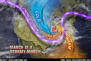
As the above AccuWeather maps show, March is usually the stormiest month of any given year, in like a lion and out like a lamb. At this moment it is playing lion role perfectly.

Flood warning update...

Go to the NWS Hydrologic Forecast page for timely information.

Some streams in the lower Delaware basin are nearing flood stage. The Delaware River at Riegelsville is rising fast but still only a bit over 5 feet (22' is flood stage). Musconetcong River is rising fast but if the rain ends, and it looks like it has for the most part as of 7:30 AM, if won't likely leave its banks.

I will be revisiting the gages late afternoon, too early to tell at this point.