Wednesday, October 25, 2006

The rivers will rise again...

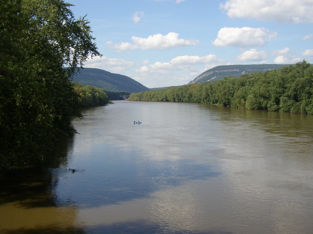
Delaware River running high below the Delaware Water Gap


A can't miss double whammy storm (see graphic here) is rolling towards the region and will be soaking us Friday and Saturday. It will be all rain, a combination of moisture from Hurricane Paul and a storm now over the Rockies (which at the higher elevations is a raging blizzard).

The Delaware River is at 5.70 on the Riegelsville gage, a bit higher than normal for this date. Most tribs are running near or slightly above normal. Everything will be running much higher by Sunday, but not at flood levels.

This Saturday I have a piano gig at the chapel in Millbrook Village, located in the heart of the Delaware Water Gap National Recreational Area. Undoubtably the nicest ride I will ever have for a piano gig, even if it is during the middle of a rain storm. After that I travel to Maine for a few days, driving a rental truck hauling the belongings of a friend. Upon return I will begin working for Amwell Valley Vineyards.

I will be a manager-in-training, which is an opportunity to learn every aspect of the business. It marks a return to my horticultural and arborist background and puts me outdoors quite a bit. I will be maintaining the vineyard, harvesting and helping the winemaker, as well as sales, events, marketing etc. They determined that my size 12 shoe size qualifies me as a promising MASTER grape stomper. I know that 250,000 pruning cuts must be done over next few months brrrrr...

Their Landot Noir and the Gewürztraminer are great and the vineyard is situated in one of the prettiest settings I've seen in the piedmont NJ (looks out over the Sourland Mountains).

The journal entries may diminsh over the next few weeks until I recover from the shock of working a real job.

Sunday, October 22, 2006

A cold winter's forecast?

Snow Day on the Musconetcong River


AccuWeather and the National Weather Service often part ways on both short-term and long-range weather forecasting. We can count on only one truth here: Each is making an educated guess and only when April 21 arrives will we learn who had it right, or for that matter if both had it wrong. AccuWeather is calling for a colder than normal January and February. NWS is predicting a generally milder than normal winter. I am hoping that NWS is more accurate. Mild winters are ideal for paddling the creeks and little rivers, and easier on the wallet too. The pessimist in me says AccuWeather will turn out to be more...accurate.

Here is what AccuWeather Chief Long-range Forecaster Joe Bastardi has to say:

AccuWeather.com Winter 2006-2007 Forecast calls for a cooler-than-normal winter along the East Coast and eastern Gulf Coast, and a warmer-than-normal winter from the western Great Lakes to the Pacific Northwest.

...Bastardi's research points to an El Niño that will remain at its current weak to moderate level, and may even weaken as the winter progresses. Because of this, a "typical" El Niño winter - such as the one predicted by the National Weather Service last week - that features warmer-than-normal temperatures across much of the U.S. is not as likely to occur.

One of these factors that Bastardi and his team expect to shape the upcoming season is the formation of a high pressure area over Greenland or northeastern Canada. This would force arctic air down into the Northeast. If this occurs as expected, the Northeast could experience severe, prolonged cold - ten days or more of temperatures averaging five to ten degrees below normal - during the middle to late winter, most likely during the month of January.

"Signs are pointing to the possibility of a rough conclusion to winter for the Northeast," said AccuWeather.com Director of Forecast Operations Ken Reeves. "Examining past years where we see similar patterns to what we expect this winter bears this out. For example, the winter of 1992-1993 was moderate until early February, when it then became colder and snowier, and culminated with a harsh blizzard on March 13. Another of the winters we see a parallel to is 1957-1958, which again began more moderately, and concluded with significantly colder temperatures and major February and March snowstorms."

Bastardi forecasts a wetter-than-average swath from Southern and central California, to the southern Plains and Southeast and up the East Coast, because an expected active subtropical jet stream will send storms on a track across the southern U.S. and likely ensure wet weather in the southern tier of the nation. How this moisture times itself with the arrival of colder air will determine how much snow the Northeast can expect, but winter is likely to be snowier than normal in the region - a mainstay of all winters since 2002. Very warm water relative to normal off all coasts provides ample moisture for any storm and timed with cold air, would lend itself to heavy snowfall in the higher elevations of the Southwest and Southeast, and also the chance for some major coastal storms on the East Coast.

For NWS/NOAA go here.

Thursday, October 19, 2006

Upper Tohickon rocks rock...


Arlene Curley is a great paddling partner. She doesn't talk much. The incessant gabbing of paddling gadflies is what keeps me away from many club trips. Babbling paddlers miss so much of the spirit of a waterway, and they scare the wildlife away too.

We met at the Ralph Stover SP take-out and put Arlene's kayak on top of my car and headed up to the Nockamixon Lake dam for the put-in. The creek was running at 2.60' at the Tohickon Pipersville gage which is a decent level for the upper Toh. It was a balmy 71 deg. air temp and water was about 60 deg.

Spectacular fall colors of hickory, maple, purple asters with the beautiful red shale and blue jingle cliffs as backdrop. The aroma of falling leaves was intoxicating. The upper creek has many beautiful shale cliffs, not a high as the lower, but unlike the class 2 and 3 lower, one actually has time to savor the scenery.

This is a hidden away stream for the most part and always has lots of wildlife. On this trip we saw many wood duck, a great blue heron that we chased all the way to the Stover dam, an osprey, red tails, a few nervous white tail deer (with racks), and a chubby beaver. The beaver never saw us coming. We watched in silent amazement as it crawled up a 50% sloped muddy bank. It finally heard my paddle as I clumsily tried to get upstream to the beaver's eddy. It saw Arlene sitting just a few feet away and FAINTED! No lie! Well, maybe lie. It literally fell back into the river, totally shocked I am sure, as beaver are very alert and wary animals. I don't think either of us have been that close to a beaver that was on the shore.

Strainers are a serious problem on the Upper Toh. In particular, there is a Paul Bunyan Ash laying across the main center channel of the creek about a mile or more below the second bridge. This is a dangerous strainer as the current is swift and channel narrow. One can pull out on river right at a braided fork (too low to enter at this level) about 20 yards upstream from the strainer and drag the boats around. At 3.00' or more the right braided channel can be run around the island. One can also pull over on river left and take another braided channel or drag around on that island, but by the time you see the big strainer you probably have missed the river left option.

Further down below Rt. 611 the river splits again with the main current heading right at the top of an island. Both of us approached this a bit too casually for our own good resulting in an unscheduled swim session for Arlene. No harm done, just a nice invigorating baptism. I was almost jealous. Last time I was "baptized" was a trip down the Tohickon in January '06 with Harold Deal. I tried to wiggle around a bridge strainer and the eddy sucked me into the abutment and the violent collision tossed me out of the Howler. Made for a chilly trip.

One more potentially dangerous strainer area that has worsened since my last visits (January and March) can be found at the broken mille dam just above a small bridge. River right, which we chose was 98% obstructed, but we were able to do an upstream ferry and get over to the main channel. However, we saw that the river-left channel that goes over the broken dam also has some strainer build-up. It is passable, but it needs to be approached carefully.

The big Stover dam portage was easy and the last few miles feature a delightfully bouncy stretch of water.

This is not a good stream for novice paddlers due to the many blind bends and strainers.

Monday, October 16, 2006

Crashing down the Mullica...


Rivergeek inspects a beaver lodge on the Mullica River during a winter '06 trip with the Outdoor Club of South Jersey.

I have been paddling solo for so long that I almost forgot how to handle a tandem canoe. Yesterday I was forced to re-learn quickly on the Mullica River in the New Jersey Pine Barrens. Sharon was my bow paddler and she can do a good draw stroke, perhaps the most important stroke on this windy, narrow and surprisingly swift stream. We were joined by Eric Sween who paddled a kayak

The stream gage read about 1.90' and any higher and we would not have squeezed under some of the low hanging trees, and I mean we were forced to lay flat in the boat to avoid getting stuck.

This is a gorgeous river that starts out below Atsion Lake at about 4 feet in width. It is an extrordinarily meandering river that flows through Atlantic White Cedar and hard wood mixed forest as well as the classic shrubby Pine Barren habitat. At one point the river opens into a lake-like savannah that features many large beaver lodges. The Mullica is a wilderness experience through Wharton State Forest, devoid of buildings and highways. It is really quiet except for the occasional intrusion of the fossil fuel addicted, stinking white trash redneck ATV rider.

Trees and shrubs grow right out over the water, making for tricky paddling. My hat was knocked off at least six times, one resulting in a near hat-sinking, but I don't mind wearing a wet hat when it's sunny and over 60 degrees.

At one point Sharon and I almost tipped, she was actually half in the water and half in the boat but I somehow got us righted, miraculously. We went flying around one of the dozens of blind curves and sideswiped a tree that was near the right shore. The only thing that prevented a cold swim was that I managed to grab the tree and force the boat back up. By then we had taken on several inches of water and became very tippy, but we found a place to dump out the water.

We put in bekow Rt. 206 at 10:30 AM and took out at Pleasant Mills about 4:40 PM (with a half hour lunch break). My understanding is that this is a 12-mile run, but it felt more like 20 (it's really close to 14 miles). That is because we were forced to duck, squeeze and careen our way through the narrow and sometimes obstructed stretches of the river.

The Pine Barren rivers are truly beautiful. But paddling one of these streams often involves a degree annoying struggle with downed trees and overhanging vegetation. A taste of the Mullica has increased my appetite for the local upland streams that I repeatedly paddle without ever having my hat knocked off my head.

The next rainstorm will bring the Musconetcong River and Tohickon Creek back up to runnable levels.

Thursday, October 12, 2006

Tougher buffer rules rule...


The following press release from Delaware Riverkeeper announces that the 300 ft. stream buffer that applies to state designated category one waterways has been upheld by the NJ Supremes, a major and welcome defeat for sprawl mongers like Hovnanian and Toll Brothers.

Streams that are not designated category one receive a 150' buffer from new land development. None of the rules apply to agricultural activities. Indeed, it has been revealed that NJDEP has abused a loophole that allows developers to apply the 150' rule to category one streams (instead of the required 300') on land that is being converted from agricultural use to development. A review of NJDEP's sneaky policy has been promised.

NJ now has some of the tougher buffer requirements in the nation. It is pretty much inconceivable that largely rural states like PA and NY will adopt similar laws. Only a few PA municipalities within the Delaware River Basin have adopted strong buffer rules, Solebury Twp. being an example.
________________________________________
300 FOOT BUFFER RULE UPHELD

NJ Supreme Court denies developers' appeal of stormwater regulations

The New Jersey Supreme Court denied the New Jersey's Builders Association petition challenging the 300 foot buffer rule contained in New Jersey's stormwater regulations adopted in 2004.

"The Appellate Division decision upholding the 300 foot buffer rule stands. We were notified late yesterday that the Supreme Court has rejected the New Jersey Builders Association Petition for certification of the buffer rule", said Carter Strickland, lead counsel in the case and Professor of Law at Rutgers Environmental Law Clinic.

New Jersey adopted sweeping stormwater regulations in 2004, which included a requirement for 300 foot buffers on either side of Category 1 streams and their drainage area. Environmental organizations in New Jersey worked for many years towards the adoption of the regulations, which have been in effect for over two years. The New Jersey Builders Association (NJBA) opposed the regulations and challenged DEP's authority to issue the regulatory requirement claiming the buffer requirement functioned as a "no build" provision "directly regulating the use of land without regard to stormwater control or management and
promulgated by the DEP without state-wide land use regulatory jurisdiction."

The Appellate Court rejected the argument In April 2006, recognizing DEP's broad authority for protecting water quality and ecosystem health. The Appellate Court stated, "The Legislature, in variety of measures, has given the DEP a wide array of power to address water
quality and pollution concerns beyond traditional floodwater control, and to promulgate rules to protect the waters of the State." The correlation of riparian land use and water quality was noted in the Appellate ruling.

"The Supreme Court's denial to hear the NJBA's challenge reaffirms DEP's powers and sets national precedent for stormwater management", said Maya van Rossum, the Delaware Riverkeeper. "The lesson learned here is that environmental regulators can and should approach stormwater management in a comprehensive manner, preventing runoff and
pollution by keeping natural systems intact", said van Rossum.

"This validation sets the record straight about the importance natural stream systems play in the protection of water quality and stormwater management", said Eric Stiles, Vice President for Conservation and Stewardship, NJ Audubon Society. "This is great news for our streams
and their habitat".

"This decision will strengthen protection of local waterways and help municipalities plan for protection of their stream corridors," said Sandy Batty, Executive Director, Association of New Jersey Environmental Commissioners.

Other states across the nation have been watching the NJBA's attack on NJDEP's powers to regulate and protect the environment. The decision marks the end of the road for this legal challenge.

Wednesday, October 11, 2006

We've only just begun...to paddle


The Delaware River at the Riegelsville gage is down to about 4.70 and slowly falling. Tributary streams are going down as well.

I am contemplating a trip on the Mullica River this weekend, let me know if you want to go. The Pine Barrens streams are lovely this time of year when there is enough water.

The cold weather paddling season is about to begin. It's the time of year that the small streams are high enough to paddle and the big rivers are ofter too windy. More importantly one can paddle in relative peace and tranquility, which is the way it's supposed to be. That is because all the fossil-fuel addicted jetskiers are absent and there are few power boats. These jerks can make paddling the river a lousy experience, and that is pretty hard to do.

The rivers and creeks all take on such a different look with the dormant and dead vegetation, frost, ice formations, and snow. The winter light is so beautiful on the water.

My favorite late fall through early spring paddling stream is the Musconetcong River, which cuts deeply into the limestone valley. I have paddled on the Musky in extremely windy weather (30 mph) and the tree tops are blowing like crazy, but there is only a wisp of a breeze on the water. A downside is that the Musky flows west, and with the sun lower in the sky this time of year, forgetting sunglasses can be a major mistake when paddling in the afternoon.

The Tohickon Creek (shown in the above pic) is another sweet local stream to paddle in cold weather, although it doesn't hold water nearly as well as the Musky and that is totally a function of geology.

The cold weather paddling requires a lot more effort in terms of preparation, especially having adequate clothing. I use a fleece-lined wetsuit that is quite comfortable, wind and rain resistant and padded in the knees for the obligatory kneeling. Under that I wear silk underwear and over the wetsuit a fleece jacket, and if cold enough a supplex nylon anorak. The biggest challenge for me is keeping the hands and feet warm.

After all the problems we have experienced with high flows I can now say: Here's to a wet fall!

Thursday, October 05, 2006

RIVER CLEANUP SEASON ENDS


Operation River Bright has been postponed until next year.

We wanted the river to get back down at least to the 5' range, preferably 6 inches lower than that. Instead it has shot back to over 6' and still climbing; it will almost certainly be well-above 5’ on Saturday (Riegelsville gage). At five feet + the river is not particularly unsafe for a downriver trip (3.5’ is low flow at Riegelsville gage), but at over 5’ it can be hazardous to be making repeated landings on shore in search of trash because the river is up in the shrubs and trees – creating what paddlers refer to as "strainers" (let's the water through but not you). This greatly increases the possibility of folks dumping and even pinning their boats.

We have excellent safety and river rescue people on these river cleanups, so if we had a HOT sunny day in store maybe we could live with the water level being a little high but...

The air temp at the planned registration time will be in the upper 40's and the high is predicted to be about 62 deg. with a 15 mph northerly wind, and water temp will be about 60 deg. For those not wearing wool, fleece, wetsuits, dry suits etc., hypothermia becomes a serious concern. And of course, the people least likely to have proper river attire would be the most likely to take an impromptu swim complete with blue lips and chattering teeth.

Early October usually brings gorgeous weather and low water levels. Not this year. Indeed, 2006 has been a year of high flows and crazy weather, including of course the 4th all-time record flood in early July, which brought a new plague of trash and litter. We will all hope and pray for no more floods I am sure, and get back out there to remove as much trash as we can from this world class river in 2007.

On behalf of the Delaware River Greenway Partnership I offer a heartfelt thanks to all who have helped or otherwise supported Operation River Bright this year. Our September 23 cleanup between Bulls Island and Hendricks Island greatly improved that trash-plagued stretch of river.

A special thanks to the National Canoe Safety Patrol - Lower Delaware Chapter, New Jersey Youth Corps of Phillipsburg, American Canoe Association, Mohawk Canoe Club, National Park Service, Lower Delaware Wild and Scenic River Management Committee, Keller’s Landing and Delaware River Experience, Hunterdon County Parks & Recreation, Lazy River Adventures (canoes), PA Department of Conservation and Natural Resources - Delaware Canal State Park
(for supplying a dumpster, gloves, bags and encouragement), ShopRite of Flemington (gloves, bags, bottled water), and Allied Waste (for offering a free dumpster).

See you on the water....

Monday, October 02, 2006

River rises...slowly falls


NJ Youth Corps members take delight in 2-mile river trip to Hendricks Island during the September 23 river cleanup. Their smiles changed to furrowed brows at the sight of the glacial piles of trash infested flotsam & jetsam that awaited them on the island.

OPERATION RIVER BRIGHT October 7

CALL TO BOATERS - WE NEED HELP! .......It looks like conditions will be favorable for the river cleanup this Saturday. I am doing my best to intervene with the river gods and goddesses to lower the water about a foot, and bring a sunny day for folks who are coming out to make our beautiful river even more beautiful by attacking the blight of trash and litter that degrades the Delaware River.

The Delaware River rose over a foot-and-a-half at the Riegelsville gage on September 30, which was scheduled to be the second '06 river cleanup. Conditions were marginal at best that day, to the point that we may have cancelled anyway. Now it's looking like October 7 will turn out to be a much better day in the important ways.

The river has flat-lined after falling back down to 5.74' and that is -- as always -- due to the higher than normal flows in many upstream tributaries. Once again the Poconos received most of the precipitation, and the Lehigh River being the second largest tributary in flow and watershed size (Schuylkill River #1), exerts a profound influence on the Delaware in oh-so-many ways, and not usually in healthy ways.

Right now the Army Corps is blasting water from FE Walter Reservoir, a flood control dam situated a few miles upstream of Whitehaven, PA, at a rate of 1300 cubic feet per second, an increase over the previous three days of between 700 and 1000 cfs continuous releases.

The NYC reservoirs are near capacity (98%). If and when the agreement to keep the reservoirs at or below 80% is approved by all parties that will change.

On the Jersey side the Flatbrook, Paulinskill and Pequest are flowing slightly higher than normal and the Musconetcong River isn't even canoeable at 1.74.' On the PA side the Tohickon is falling back to normal low levels, and the Lackawaxen River, Bushkill Creek and Brodhead Creek are running higher than the seasonal mean, but slowly coming back down.

All this means that the Delaware River will cease flatlining as soon as the upper watershed streams fall, and it will fall even more when the Army Corps closes the gates at the FE Walter Dam.

The Delaware River Basin Commission's monthly hydrologic report summarizes rainfall data for stations near the river at Montague, Trenton and Wilmington. Unfortunately this river-centric data set does not tell the true story as it shows Trenton with the highest total. The upper basin received much more rain since January 1 according to NWS data. For example the Mt. Pocono station records 12.63" total rainfall above the yearly average so far this year (about 5" more than Trenton on the Delaware).

The great news is that we could have been - but weren't - hammered by 2 or 3 big storms that were pushed to the northeast to pound the British Isles and maritime Canada.