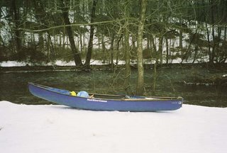
 Snow Day on the Musconetcong River
AccuWeather and the National Weather Service often part ways on both short-term and long-range weather forecasting. We can count on only one truth here: Each is making an educated guess and only when April 21 arrives will we learn who had it right, or for that matter if both had it wrong. AccuWeather is calling for a colder than normal January and February. NWS is predicting a generally milder than normal winter. I am hoping that NWS is more accurate. Mild winters are ideal for paddling the creeks and little rivers, and easier on the wallet too. The pessimist in me says AccuWeather will turn out to be more...accurate.
Here is what AccuWeather Chief Long-range Forecaster Joe Bastardi has to say:
AccuWeather.com Winter 2006-2007 Forecast calls for a cooler-than-normal winter along the East Coast and eastern Gulf Coast, and a warmer-than-normal winter from the western Great Lakes to the Pacific Northwest.
...Bastardi's research points to an El Niño that will remain at its current weak to moderate level, and may even weaken as the winter progresses. Because of this, a "typical" El Niño winter - such as the one predicted by the National Weather Service last week - that features warmer-than-normal temperatures across much of the U.S. is not as likely to occur.
One of these factors that Bastardi and his team expect to shape the upcoming season is the formation of a high pressure area over Greenland or northeastern Canada. This would force arctic air down into the Northeast. If this occurs as expected, the Northeast could experience severe, prolonged cold - ten days or more of temperatures averaging five to ten degrees below normal - during the middle to late winter, most likely during the month of January.
"Signs are pointing to the possibility of a rough conclusion to winter for the Northeast," said AccuWeather.com Director of Forecast Operations Ken Reeves. "Examining past years where we see similar patterns to what we expect this winter bears this out. For example, the winter of 1992-1993 was moderate until early February, when it then became colder and snowier, and culminated with a harsh blizzard on March 13. Another of the winters we see a parallel to is 1957-1958, which again began more moderately, and concluded with significantly colder temperatures and major February and March snowstorms."
Bastardi forecasts a wetter-than-average swath from Southern and central California, to the southern Plains and Southeast and up the East Coast, because an expected active subtropical jet stream will send storms on a track across the southern U.S. and likely ensure wet weather in the southern tier of the nation. How this moisture times itself with the arrival of colder air will determine how much snow the Northeast can expect, but winter is likely to be snowier than normal in the region - a mainstay of all winters since 2002. Very warm water relative to normal off all coasts provides ample moisture for any storm and timed with cold air, would lend itself to heavy snowfall in the higher elevations of the Southwest and Southeast, and also the chance for some major coastal storms on the East Coast.
For NWS/NOAA go here.


No comments:
Post a Comment