Friday, June 30, 2006

First dry day of summer!


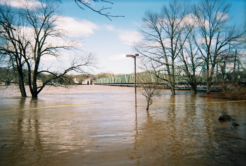
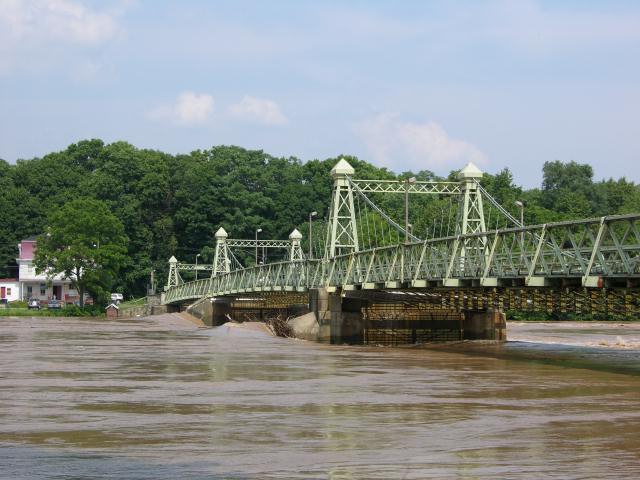
Thanks to Siobhan Royack for the above pic of Riegelsville Bridge at flood crest!

According to an article in today's Philly Inquirer the Lambertville sewage and dechlorination plants were under water yesterday morning. The river is already contaminated by raw sewage from an infinite variety of sources. But there is also the possibility of contaminated drinking water supplies (gulp! I drink bottled water). Imagine how difficult it is for the Trenton water treatment plant to produce clean drinking water under these conditions (see last post for a tasty description of current water quality). The aforementioned article gives a good summary of flood woes in the region.

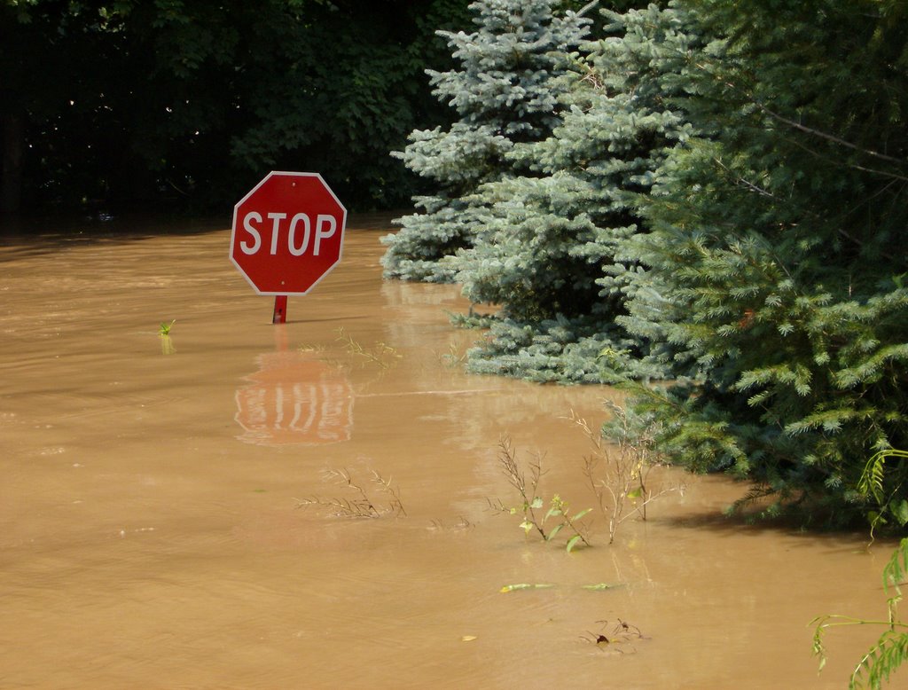
The river at Riegelsville has dropped to just under 16' and that is difficult to believe considering it was at a ripping 32.07' yesterday, but it generally reflects the dropping water levels everywhere else.

Here is a look at historic flood crests for Belvidere, Easton/Pburg, Rieglesville, and New Hope. 1955 is still the record with April 05 coming in at #3, except for Easton, where the 6/29/06 flood has moved into the 3 spot.

Belvidere: (Flood stage is 22')
6/29/06 (27.16'); 4/4/05 (27.24'); 8/19/55 (30.21')

Riegelsville: (Flood stage is 22')
6/29/06 (32.98'); 4/3/05 (34.07'); 8/20/55 (38.85')

Here are comparisons for Easton and New Hope (or Phillipsburg and Lambertville if you are in NJ)

The Easton/P-burg Bridge: (Flood stage is 22')
6/29/06 (37.09'); 4/3/05 (36.5) 8/20/1955 (43.7' )

New Hope/Lambertville Bridge (Flood stage is 13')
6/29/06 (18.13' ), 4/3/05 (19.07') 8/20/55 (24.3')

The numbers, when comparing different points along the river, can't be taken at face value. New Hope was hammered by flooding at 18.13 and Easton at 32.98. New Hope was about 5' over flood stage, which is enough to affect businesses and residents along Main Street.

Easton, PA and Phillipsburg NJ, situated at the Forks of the Delaware (Lehigh River confluence) were FIFTEEN FEET over flood stage. As I have been saying all along, this event has mostly been about the Lehigh River and the 13 inch plus rain that fell on the Poconos, also impacting many other tributaries on the PA side, most notably the Lackawaxen River, which next to the Lehigh, is the largest non-tidal trib on the PA side.

I have already heard the word on the street and comments from friends that this flood was the result of 1) global warming; 2) too much development; 3) untimely releases from the NY reservoirs.

I have yet to hear anyone say TOO MUCH RAIN!

Last year I wrote an article about the April 05 food debunking claims # 2 and #3. It can be found on the Delaware River Greenway Partnership website, if you can deal with their squirley Macromedia Flashpaper. It's titled "View From the Canoe" and begins on page 8. Let's blame "too much development and impervious surfaces" when the ground is frozen and in some places covered with snow?

For the No Name Flood of 6/06, it is likely that a combination of all the above factors came into play. For example, the Lehigh Valley has seen a lot of development in the Poconos and in the Allentown-Easton I-78 corridor. The later is a major urban area as it has been for a few hundred years. And it has a watershes of over a thousand square miles. That is why the Lehigh is such a major player in Delaware River floods, at least for those living downstream from Easton. The NYC reservoirs overflow when they fill up, but that is not proof of a government plot to flood downstream communities.

Truth is that folks tend to assign blame to the one category that neatly fits their own bias or agenda. It's so much easier to see the world in black & white, without all those annoying gray areas.

I will be writing more about the 6/29/06 flood and related topics. Meanwhile, a few tributaries are calling my name. Off to paddle the Musconetcong River.

Thursday, June 29, 2006

STOP!


That shot of a Holland Township stop sign taken by Wally Jenness says it all. The river is clearly cresting at 32.90' at the Riegelsville Gauge, flatlining if you will, and just about everywhere else too.

Now the photos emerge, and the river will soon recede to reveal the damage done to manmade objects such as buildings, roads, and bridges. Right now the Delaware is one of the most polluted rivers on the planet, except for all the other rivers that are involved in this natural disaster. We have gas stations, sewer plants and septic systems, McDonalds frenchfrie oil, dead cows, and tons of silt mixing together in a chocolate colored, fetid mix of benzene, oil, bacteria, and pathogens.

Across the river from Wally, Siobhan Royack of Durham Township has been traveing between Kintnersville and Riegelsville, PA. she is documenting this historic, albeit depressing event, as she has done so many times before.

The photo on the right is the Riegelsville Inn, which is situated near the most beautiful bridge over the Delaware River, the Roebling cable suspension bridge.

Unless something really big happens I will take a break until tomorrow morning - I am fried!
jb

Passing the crest

Riegelsville gauge indicates the river is beginning to level off at 32.90' (it's probably a few inches higher by now). That would be little over a foot shy of the April '05 flood which was #3 all-time.

New Hope, as seen from the Lambertville shore is a disaster. The Bucks County Playhouse sits forelornly on the flooded waterfront.

Delaware Riverkeeper Network sent this too me a few minutes ago.

Delran Wastewater Plant Dumping Sewage

Delaware Riverkeeper Network received a report that the Delran Sewage Treatment Plant in Delran Township, NJ is dumping up to two million gallons an hour of partially-treated sewage out of the outfall pipe into either the Delaware River or Rancocas Creek (the location of the outfall is yet to be confirmed). Early reports say this is not an issue related to the recent rains but a malfunction of the plant and a recurring problem for the plant. NJ officials inspected the plant last week and cited problems with one of the UV disinfection stations. The plant is required to have two working UV disinfection stations and one of the stations was filthy and not operating. This is an ongoing problem at the STP and reportedly officials have concerns about inexperienced operators and/or lack of appropriate funding for proper maintenance of the facility.

Angered by the reports Maya van Rossum the Delaware Riverkeeper says “It is inexcusable that this plant has been allowed to operate at such a low level and is now doing harm to our River and threatening our communities. DEP needs to take immediate action to penalize the facility, to ensure it is upgraded and operating cleanly from here on out and that they are required to implement projects to restore health to the Rancocas Creek and Delaware River in order to make up for the harm they have inflicted.”

DRN confirmed with the Burlington County Health Department this morning that a call was put in by NJ DEP to issue a health advisory for the region. It is critical that the public stay away from the contaminated areas downstream as this is a human health issue. It is also crucial that water users of this service area refrain from using water in their home that is of non-critical use to minimize the amount of wastewater flowing into this plant.

DRN has reported the pollution discharge to the appropriate officials.

Optimistic....and wrong


The river hasn't risen much overnight, but clearly the gauge at every station below Montague is showing the tip of a new spike. Not good news. But it is good news that the Montague appears to have crested and is falling, although at 30' it is still above flood stage (25'). Port Jervis is also receding and is now going below flood stage.

Unfortunately, Belvidere and Riegelsville show slight rises. Riegelsville is at 32.84 as of 7:30 AM, which means it is likely at 33.0 by now, or 11' above flood stage. The Lehigh at Bethlehem has fallen 8.0 feet and that is great news.

The Delaware River at the Rt. 22 Bridge is at 38.0 feet. That is EIGHTEEN FEET above flood stage. This is the confluence of the Lehigh and Delaware - the Forks of the Delaware.

It appears that people won't able to return to some of the flooded towns on the Delaware until Saturday at the earliest. I will report later upon return from a visit to the Lambertville waterfront to look across at New Hope. Lambertville only floods at its most vulnerable points, which happen to be near the confluences of the 2 creeks that flow through either end of town (Swan Cr. and Alexauken Cr.). As with many other creeks, these back up and flood adjacent areas and this scenario is played out all the way up to Hancock, NY. None of those confluences are more dramatic than the Forks at Easton-Phillipsburg where the NJ Youth Corp is seeing its third devasation.

Wednesday, June 28, 2006

A slight reprieve

Yes! Small consolation for many unfortunate people, but the last post seems to be true, the predicted crest has been downgraded by about 4' (32'). So instead if 36' -- or two feet higher than April 05 -- it might crest at 32' or 33'. Regardless, this will end up as either numero 3 or 4 all time.

Of course, it is majorly humid out there, which could foretell some more heavy downpours, and a whole new spike.

I am trying to stay optimistic in the face of one of the most devastating floods in history. There are so many topics to write about but this will be the main story for the next several weeks.

Tomorrow, a tour upriver and some flood photos. And discussion of river cleanups already in the works.

Also, this is a rare event in that the flooding is not caused by snow melt, ice jams, or a hurricane. It is really reminiscent of Hurricane Agnes (1972). That is the flood of record for the Schuylkill and Susquehanna (and my home creek the Perkiomen). The Poconos and other mountain ranges saw up to five tomes the amount of rainfall than the piedmont region.

That is a huge topic of interest to be explored once the data is all in.

Maybe a break?

I'm going to stick my neck out there - again.

I suspect that the NWS/NOAA is overestimating the crest for Riegelsville (36') by the same margin that they underestimated the April 2005 flood (they missed that one by a mile).

I see the Lehigh heading down, and I now see the Delaware River at Riegelsville appears to be turning a corner.

It is still a serious event, but maybe, just maybe it won't exceed 2005.

We will know the truth in a few hours.

Cooks Creek


Thanks to Siobhan Royack for this back porch shot of Cooks Creek. She and Mark weathered the April Flood ok but got pounded by Ivan in 05.

I hope you make out ok, will get in touch.

I have been receiving interesting reports from folks around the lower Delaware.

Check the comments section of the last few posts!

Mid-Day Report

The Delaware River at Riegelsville reads 29.01' and that puts it on the predicted track to reach 30' by 2:00 PM. It will likely reach at least 35' by dusk, as predicted. The Lehigh at Lehighton is receding and the Lehigh at Bethlehem is just beginning to recede, which is good news for the Delaware, a first step. But the Delaware still may not begin to recede until tomorrow morning (approx 8AM). There is still an 8' gap between the river at Belvidere and Riegelsville. The Lackawaxen at Hawley has also just started to recede. It is way over flood stage.

The USGS server is very slow and the NOAA Hydrologic Forecast System does not work well - about 50% of attempts to access have failed. They have an online comment section, on which I reported the problems. This new system is UTTERLY USELESS if it can't be accessed when it is needed. Anyone else having difficulty? Please let me know. I can bring this up with the folks at DRBC and NOAA.

Spole with Mayor Rackin of Stockton this morning, he is ordering evacuation at 1:00 PM.

Just got back from Frenchtown and Rt. 29 is closed at Wickecheoke in Stockton and at the unpronounceable creek in Frenchtown. Frenchtown Bridge is closed, others will soon follow except for Rt. 202 toll, I-95, Rt. 22 etc.

This will go down as one of the most unusual floods, in that all the others have been associated with snow and ice melt or hurricanes. The No Name Flood? I spent a few minutes at the Frenchtown Bridge speaking with Mayor Sworen and locals. Some are already searching for something (or somebody) to blame for this event. The usual suspects? Reservoir releases and upstream development. I am blaming Bush.

Where will the No Name Flood of '06 fit in?

Historical Crests

(1) 38.85 ft (1955 - August 20)
(2) 35.90 ft (1903 - October 10)
(3) 34.07 ft (2005 - April 3
(4) 32.45 ft (1936 - March 19)
(5) 30.95 ft (2004 - September 19)

News from upriver

Here is a message from the Classical Guitar Duo Laura Oltman and Michael Newman who reside on River Road in Pohatcong Twp., just above Riegelsville. Thanks Laura and Michael for valuable info.

Dear friends,

Very bad news this morning at 6:28 am. The river is now expected to rise to
36 feet at Riegelsville, which is 2 feet higher than the flood in April
2005. At that time, we had 6 feet of water in our basement. If
predictions hold, we will come very close to lapping at the floor joists,
but we may be safe for the first floor.

Most of our neighbors will be devastated. Here is the page we have been
checking:

http://newweb.erh.noaa.gov/ahps2/hydrograph.php?wfo=phi&gage=rgln4&view=1,1,
1,1,1,1


If you go to it and leave it up, you must refresh it from time to time for
the latest forecasts.

Check out this site, too: (note: you are already there!)

http://delawareriverjournal-rivergeek.blogspot.com/

Here is the phone number direct to the Riegelsville Gauge:
908-995-4739 (listen after the long tone)


What we have heard Wednesday AM:
21.37 at 2:24 am

21.45 at 3:24 am

21.67 at 4:08 am

24.32 at 7:24 am

New Forecast from NOAA as of 6:28 am:
30 feet at 2:00 PM Wednesday
35 feet at 8:00 PM Wednesday
36 feet at 2:00 AM Thursday
36 feet at 8:00 AM Thursday
35 feet at 2:00 PM Thursday
30 feet at 2:00 AM Friday

April 2005 was 34.07 feet
August 1955 was 38.85 feet

Rain has stopped in Lambertville

Riegelsville is officially at flood stage with a current reading of 22.79, and still predicted to reach 36' around 2AM Thursday morn; and let's hope it never reaches that level. Lehigh River is now at flood stage in Bethlehem (still rising) and Lehighton (beginning to fall). There is now an 8' gap between Belvidere gauge and Riegelsville, which hopefully means folks upriver from the Lehigh confluence won't be hit too hard.

Blue skies and an emerging sun!

Raining heavily at 4:30AM

The NWS prediction service now has the Delaware at Riegelsville cresting at 36', which would be about 2' higher than April 2005 (34.07). The river at Belvidere is predicted to crest around 27'.

Ecological and economic devasatation would be the immediate result if such predictions unfold, particulary between Easton and Trenton. Oddly, the prediction service doesn't indicate any particular crest right now, but that being the Lehigh confluence, one would expect to see only the roof of the downtown McDonalds.

The graph for Trenton only predicts moderate flooding, which is certainly out of sync with the dire Riegelsville prediction.

The Wickecheoke Creek, a NJ trib a few miles iup the road had risen from 3' to over 6' and that will go up to perhaps 10' at this rate.

Other major NJ tribs (Musconetcong - Pequest - Paulinskill) are just beginning to come up.

Most of the PA tribs actually started to fall around midnight but they are heading back up, some of these are already at or above flood stage, most notably the Lehigh. Even the Delaware looked like it was about to level off at midnight. But it too will be rising quickly again from near bank full to who knows what level.

I don't know how to go back to sleep, but another hour of snooz would be nice before the tour upriver.

Tuesday, June 27, 2006

UNBELIEVABLE

There is a forecasted crest of the Delaware River in Rieglesville at a level of between 32 and 34 feet. They expect crest early Thurs am. This will come close to or maybe even exceed the devastating flood of April 2005.

The difference between Belvidere gauge and Riegelsville is really significant - nearly SIX FEET!

And the difference can be explained in 2 words - Lehigh River. The Poconos have been pounded for days. The Schuylkill River headwaters are adjacent to the Lehigh and the Schuylkill may exceed its record flood (Hurricane Agnes - 1972). Fortunately that will not impact the Delaware.

But the Lehigh continues to rise, and with the new wave of storm cells, our Piedmont tribs may begin to contribute to the problem.

UPDATE

National Weather Service latest prediction for Riegelsville is now at 26'.

THE NATIONAL WEATHER SERVICE IN MOUNT HOLLY NJ
HAS ISSUED A FLOOD WARNING FOR THE DELAWARE RIVER
AT RIEGELSVILLE

FROM WEDNESDAY MORNING UNTIL LATE FRIDAY.

AT 12 PM TUESDAY THE STAGE WAS...16.1 FEET.
MODERATE FLOODING IS FORECAST.
FLOOD STAGE IS 22.0 FEET.

FORECAST TO RISE ABOVE FLOOD STAGE
BY TOMORROW MORNING AND CONTINUE TO
RISE TO NEAR 26.0 FEET
BY EARLY THURSDAY MORNING.

FLOOD WARNING

THE NATIONAL WEATHER SERVICE HAS ISSUED A FLOOD WARNING FOR THE LOWER DELAWARE RIVER.

The river is predicted to rise to 25' by tomorrow morning at Riegelsville, which is 3 feet above flood stage, enough to cause moderate flooding of some roads and the more vulnerable river dwellers.


If you live along the river or a creek in the lower Delaware River watershed, please pay attention to the weather forecast this evening, and you might want to set your alarm for 2AM to check on conditions outside, and check stream gauges and rainfall amounts in the upper watershed, especially the Lehigh, Lackawaxen, Musconetcong, and Paulinskill Rivers, and Brodhead Creek (the Poconos have had the most rain).

NOAA is sending out a plane off the coast of the Outer Banks, NC (one of my favorite destinations) to asess what they describe as a developing "tropical depression." As if that's not depressing enough we are getting small bands of precip coming up right now. If a tropical depression develops it has the potential to move quickly up the coast and bring some stormy weather with up to 4" more rain and strong winds.

This is not a certainty, at this point, we can hold out hope that it will fizzle. Another inch won't be dire, but 4 or more would be a problem.

Right now the Lehigh River is above flood stage at Walnutport and Lehighton. The Lackawaxen is also closing in on its flood stage. The Schuylkill will be flooding in Reading (not a concern for the Delaware). Clearly most of the precipitation has thus far fallen along the Appalachians (Poconos) and much less has fallen in the Coastal Plain and a little less in the Piedmont, but that could change with a tropical depression. The NJ tribs are not running high, in fact some are just high enough to paddle (Pequest, Paulinskill. Musconetcong). The Flatbrook is running a bit higher, being on the other side of Kittatinny mountain.

More to follow.

A flood in the works?

Why do these things always seem to develop overnight? Just received a NOAA alert from Joe Pylka that if realized could take the lower Delaware and some of its tributaries out of their banks tonight or tomorrow morning. Please keep track of this situation. I will be posting an update tonight around 10 PM and as early as I can do it tomorrow morning (probably between 5:30 and 6:30 AM).

The river has risen over 12' within the past 30 hours or so, which is remarkable for a large river. It's closing in on 16' at Riegelsville with another 6' to go before it reaches bank-full. Most people along the river aren't impacted at 22'. It takes another 2 feet or so to begin reaching the most vulnerable river dwellers.

Clearly the Lehigh River is the most impacted (and largest) tributary to the Delaware. The difference can be seen upstream (Belvidere) and downstream (Riegelsville).

Special Weather Statement
NATIONAL WEATHER SERVICE MOUNT HOLLY NJ
1115 AM EDT TUE JUN 27 2006

VERY HEAVY FLOOD PRODUCING RAINS,
AND NOW THE THREAT OF SEVERE THUNDERSTORMS...

THE REGION HAS BEEN UNDER A FLOOD THREAT FOR SEVERAL DAYS,
AND NOW THERE IS A THREAT OF SEVERE THUNDERSTORMS,
AND POSSIBLY ISOLATED
TORNADOES.

Click on the above link to read entire forecast.

River Rising

The river at Riegelsville gauge continues to surge upwards near 13' with rain forecast for today and ending tomorrow. It appears that the Lehigh Basin received some more heavy rain last night, given the recent mini-spike, but the only station to reach flood stage was the Lehigh River at Walnutport.

Does anybody know why Walnutport is the only Lehigh station to exceed flood stage? Seems odd.

I am still optomistic that the Delaware will not exceed flood stage at 22' in Riegelsville. It all depends on what happens upstream.

I have a number of river trips that are facing extinction if the river does not recede back below 5' before next week. Nine days on the river with Girl Scouts from Hunterdon County.

Tomorrow I was planning to join Fred Stine and Faith Zerbe of Delaware Riverkeeper Network to take the Riverkeeper boat from Bristol, PA to Penns Landing in Philly. I haven't had many opportunities to do any boating in the tidal Delaware, but current conditions could scuttle this trip.

An alternative for tomorrow is to accompany a reporter from the Hunterdon Democrat on a canoe trip from Frenchtown to Bulls Island, but that seems even more unlikely.

I will lilely do an update later today.


-- "Go to Heaven for the climate, Hell for the company." Mark Twain

Monday, June 26, 2006

Minor flooding is occuring in several streams around the Delaware River Basin. Lehigh River at Walnutport is just above flood stage this evening. For a great resource to find out what is going around the watershed go to the Delaware River Basin Commission flood page here.

The Delaware River at Riegelsville is rising (just under 8.oo', double the level this morning, but at this point in time it doesn't look like it will reach flood stage (22'), unless we get two more days like today.

River rats, meaning those who live close enough to the river to see it lapping at the back door should join DRBC's Automated Email Flood Warning System. The system retrieves daily river forecasts from eight stations around the watershed. "If the forecasted stages exceed the station-specific Flood Action Level, the program generates and sends an e-mail warning to a List Server. By subscribing to the List Server, individuals can get e-mail warnings about NWS-forecasted flood events on the main stem Delaware River, the Lehigh River, and the Schuylkill River."

Today I met with representatives from the Musconetcong Watershed Association, NOAA, American Rivers, and USDA - NRCS to tour dams on the lower Musky below Hackettstown down to Finesville. We discussed a tentative plan that would envision putting together cost estimates to remove or breach the bottom 4 dams, one of which is over 30' high, a huge dam for such a small river, located in the gorge above the Warren Glen paper mill. My role was to tell them where all the dams are located. There is no better way to learn about dams than to frequently canoe the stream in question.

The NJDEP database lists several that have been completely washed away. The Musconetcong Wild and Scenic River Management Plan calls for a comprehensive program to remove dams to improve water quality, reduce flooding, and restore migratory fish to the river (American Shad).


Looks like the Upper Delaware and Lehigh River watershed were pounded as stream levels doubled overnight. All the tribs saw spikes, like this one. The lower Delaware is rising in response the heavy rain up north.

This morning I am meeting folks from the Musconetcong Watershed Association to look at all the dams below Hackettstown, at least the ones we can get to. Princeton Hydro engineer and someone from American Rivers will also be there. I was invited because I actually know where the dams are and who owns them. More on that later today. Gotta run.

Sunday, June 25, 2006

The river at Riegelsville is leveling off at about 4.20', which is a bit above the mean daily flow. It's muggy, depressingly dark and more rain is forecast for today, possibly heavy, but overall this has been a beneficial weather system that is helping restore soil moisture and the base flow of the tributaries, which have all been running low this spring. Most of the tributaries have only seen moderate increases in flow, although the Tohickon Creek shot up from 1.5' to 4.5' yesterday, but it has since fallen back to around 2.00' this morning.

Dee Keller of Keller's Landing in Upper Black Eddy called to ask about a six inch spike in the Delaware on June 19 (overnight). A few minutes of tracing stream gauges from Riegelsville and upriver revealed that the Lehigh River and its tributaries had an even bigger spike. Dee observed that water clarity diminshed overnight. That was due to the intense storm cell that dumped over 2 inches of rain on all those Lehigh Valley corn fields, construction sites and city streets. The Lehigh is the single greatest source of pollution to the non-tidal Delaware River, and that can be seen in the form of algal growth on the river bottom. One can easily observe the difference above and below the Lehigh confluence. The Lehigh is also the second largest tributary to the Delaware with a watershed that is slightly smaller than the Schuylkill River, the largerst trib, which runs into the Delaware in southwest Philly.

Friday, June 23, 2006

Worrisome Weather Pattern

The river actually fell below 4.00' (Riegelsville gauge) for the first time in many months, but the forecast indicates that will be a short-lived drop. The stalled high pressure is allowing bands of heavy storms to drift up the coast and this could bring several inches of rain.

All the major non-tidal tributaries (Lackawaxen, Lehigh, Musconetcong, Tohickon) are at or below daily median flow as of this morning. It will be interesting to see how the predicted heavy storms impact the watershed.

Saturday, June 17, 2006

Welcome to the Delaware River Journal


By way of introduction, the Delaware River Journal (DRJ) is an open-ended discussion of the widest possible range of topics related the RIVER. The DRJ is dedicated to all the many people who care about the Delaware River and its tributaries, especially the legions of activists who work in their own communities and watersheds to protect environmental quality around the 13,539 square mile river basin.


There are so many people out there who have an abiding respect and affection for the Delaware River. These relationships between people and the river take on many forms. For some it is the fishing boat and lure of landing a small mouth bass or shad, for others the view at sunset from the bridge or back porch, the canoe paddle carving a path through the current, or the refreshing plunge from the rope swing or pontoon boat.

In my case it was love at first sight, although I have since come to know this river on so many different levels. The relationship was born out of a deep affinity for and professional work on behalf of moving water environments -- mainly creeks, rivers and their watersheds.

Nearly twenty-five years ago I moved into a log cabin situated in a mature floodplain forest along the Perkiomen Creek, largest tributary to the Schuylkill River, itself being the largest Delaware River tributary. That nearly eight year chapter in my life began a total immersion in the infinite array of topics having to do with moving water.

When I came to work for Delaware Riverkeeper Network in 1992 the learning curve accelerated. That job and subsequent positions working on behalf of Delaware River tributaries such as the Musconetcong, Tohickon, Lackawaxen, and Wickecheoke to name a few, put me in touch with so many dedicated people who give so much more than they take.

The frequency of new posts to this Journal will be dictated by how much time is available to write, and by the condition of the river and urgency of issues surrounding it. I welcome your comments and hope this will be a catalyst for others who share an interest in the river and its tributaries.

Naturally, much of what is written here will come from my frequent trips down the river, the View From the Canoe will rule.

Speaking of which, yesterday I paddled a great stretch of river between Raubs Island and the Indian Rock Inn,
which is nestled in the lower end of the Nockamixon Palisades. The "IR" is one of my favorite haunts, a friendly country inn with great food and live music. It is a lovely way to end a canoe trip, except for the difficulty of taking out at a poison ivy and nettle infested steep path.

This stretch of the river cuts through the Reading Prong (Highlands), passing some fine limestone streams including the Pohatcong Creek, Musconetcong River, and Cooks Creek. Then the river enters the red Triassic rock of the Piedmont region, which is wonderfully displayed by the aformentioned bluffs and further downstream on the NJ side, the Milford Bluffs. One of the great things about living in this region is one can always determine the local geology by looking at the houses, barns, canal walls and churches built from local stone. Stand at the head of any island in the lower Delaware and one can see every type of rock found upstream in the watershed.

The river was running at around 4.60' at the Riegelsville gauge, a nice flow that is about a foot higher than the daily mean. The water clarity is coming back and the short range forecast suggests that the river will continue to fall to seasonal levels. Observed a mature bald eagle flying above the tree tops at Traugers Farm Market.

See you on the water.

Friday, June 09, 2006

Trash Hunting on Hendricks Is.

Wally Jenness looks at canoe buried in flotsam on Hendricks Is


June 9, 2006

The Riegelsville gauge read just under 6 feet, about a foot higher than the median daily flow and much higher than it has been in previous years when we experienced early drought conditions.

I am taking representatives from the Bucks County Native American Alliance to Hendricks Island to let them see the enormity of doing a river cleanup. They approached the Delaware River Greenway Partnership, an organization that has sponsored several river cleanups under the banner of Project River Bright.

The April 2005 flood (number six all time) deposited untold tons of trash scattered on the upper end of the island. Most of the trash is interspersed with tree trunks, limbs, woody debris in flotsam piles that are over twenty feet high -- one such pile is about 150 yards long and 30 yards wide. Plastic, metal and glass containers, propane tanks, household items. The flood swept out the contents of many river rat cottages, garrages, and back yards.

A cleanup of Hendricks Island would be a multi-year effort. There is more trash strewn about that island any other place along the entire non-tidal river.