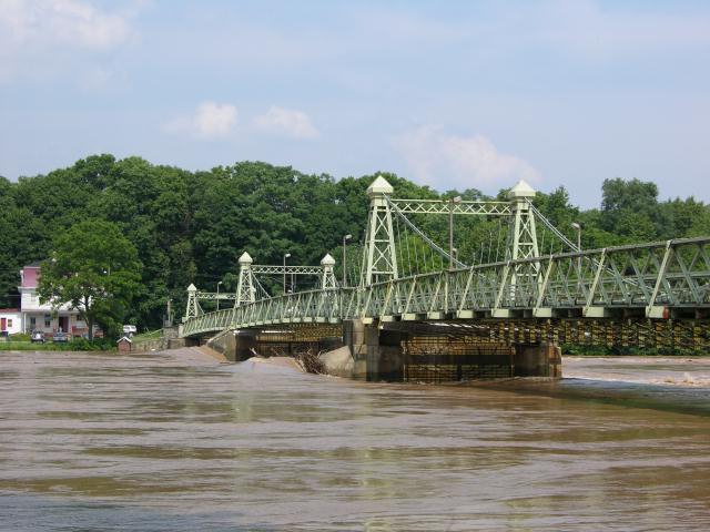
Thanks to Siobhan Royack for the above pic of Riegelsville Bridge at flood crest!
According to an article in today's Philly Inquirer the Lambertville sewage and dechlorination plants were under water yesterday morning. The river is already contaminated by raw sewage from an infinite variety of sources. But there is also the possibility of contaminated drinking water supplies (gulp! I drink bottled water). Imagine how difficult it is for the Trenton water treatment plant to produce clean drinking water under these conditions (see last post for a tasty description of current water quality). The aforementioned article gives a good summary of flood woes in the region.
The river at Riegelsville has dropped to just under 16' and that is difficult to believe considering it was at a ripping 32.07' yesterday, but it generally reflects the dropping water levels everywhere else.
Here is a look at historic flood crests for Belvidere, Easton/Pburg, Rieglesville, and New Hope. 1955 is still the record with April 05 coming in at #3, except for Easton, where the 6/29/06 flood has moved into the 3 spot.
Belvidere: (Flood stage is 22')
6/29/06 (27.16'); 4/4/05 (27.24'); 8/19/55 (30.21')
Riegelsville: (Flood stage is 22')
6/29/06 (32.98'); 4/3/05 (34.07'); 8/20/55 (38.85')
Here are comparisons for Easton and New Hope (or Phillipsburg and Lambertville if you are in NJ)
The Easton/P-burg Bridge: (Flood stage is 22')
6/29/06 (37.09'); 4/3/05 (36.5) 8/20/1955 (43.7' )
New Hope/Lambertville Bridge (Flood stage is 13')
6/29/06 (18.13' ), 4/3/05 (19.07') 8/20/55 (24.3')
The numbers, when comparing different points along the river, can't be taken at face value. New Hope was hammered by flooding at 18.13 and Easton at 32.98. New Hope was about 5' over flood stage, which is enough to affect businesses and residents along Main Street.
Easton, PA and Phillipsburg NJ, situated at the Forks of the Delaware (Lehigh River confluence) were FIFTEEN FEET over flood stage. As I have been saying all along, this event has mostly been about the Lehigh River and the 13 inch plus rain that fell on the Poconos, also impacting many other tributaries on the PA side, most notably the Lackawaxen River, which next to the Lehigh, is the largest non-tidal trib on the PA side.
I have already heard the word on the street and comments from friends that this flood was the result of 1) global warming; 2) too much development; 3) untimely releases from the NY reservoirs.
I have yet to hear anyone say TOO MUCH RAIN!
Last year I wrote an article about the April 05 food debunking claims # 2 and #3. It can be found on the Delaware River Greenway Partnership website, if you can deal with their squirley Macromedia Flashpaper. It's titled "View From the Canoe" and begins on page 8. Let's blame "too much development and impervious surfaces" when the ground is frozen and in some places covered with snow?
For the No Name Flood of 6/06, it is likely that a combination of all the above factors came into play. For example, the Lehigh Valley has seen a lot of development in the Poconos and in the Allentown-Easton I-78 corridor. The later is a major urban area as it has been for a few hundred years. And it has a watershes of over a thousand square miles. That is why the Lehigh is such a major player in Delaware River floods, at least for those living downstream from Easton. The NYC reservoirs overflow when they fill up, but that is not proof of a government plot to flood downstream communities.
Truth is that folks tend to assign blame to the one category that neatly fits their own bias or agenda. It's so much easier to see the world in black & white, without all those annoying gray areas.
I will be writing more about the 6/29/06 flood and related topics. Meanwhile, a few tributaries are calling my name. Off to paddle the Musconetcong River.


2 comments:
John, Your narrations and photos are the best description of this flood that I have seen yet. Thanks for keeping it updated.
Elizabeth
John,
Do you have any idea of how many square MILES of land are being used by the NYC reserviors? If the reservoirs are filled to capacity, which should not be permitted, are they any different than the parking lots and other impervious surfaces that are being created?
Just as new developments are required to provide retention (water) based upon the amount of impervious surfaces created, should not the reseviors provide retention for the many square miles that have been filled with water and can no longer absorb the rain?
Seems like the river geeks, like yourself, were able to force the reservoirs to release water, when it is most scarce at the reserviors but river residents cannot get the water maintained at a lower level when water is plentiful. Maybe we need another reservior (kept empty) to take up the slack that was to be done by Tock's Island.
Thanks for listening to other points of view.
Don J. (a flooded river rat)
Post a Comment