Monday, March 05, 2007

Views from the canoe...


The Howler points at one of the ugliest farms in the region, a veritible factory of goose and steer manure that washes directly into the river over denuded stream banks, broken and eroded by the aforementioned critters. Almost enough to make one wish for a cul-de-sac subdivision. Other pic is the patriotic car wash in Hackettstown as seen from the center of the river.


It's just too cold to paddle today, 35 deg with 35 mph wind and chance of snow squalls. For shame because the Musconetcong is running at 2.30, not great but adequate and near the average daily mean (88 years of record).

Still thrilled that the Musky achieved National Wild and Scenic River status. It took nearly 13 years from the time the first petition was circulated to the 109th Congress eleventh hour decision to approve and subsequent signature by the POTUS.

The river still has serious problems from ag runoff, urban impacts from Hackettstown (see the photos at top of post), interstates and such like. The most important thing is to do no more harm and a Category One stream designation for the mainstem would be helpful. Dam removals are in the works, we have one plan, devised by Princeton Hydro, that would take out the first four lowhead dams from the Delaware confluence up to Bloomsbury. Make that 3 lowhead dams. One of the dams is 30 ft. high and it made the most wild stretch of river ineligible for W&S designation. It must and eventually will go, but will cost a small fortune.

There is also a mini-watershed management project starting up for a discreet section of the river between Hampton and Bloomsbury, which also happens to be a favored canoeing stretch at lower water levels. I could and probably will write a book about the sordid story of watershed management in the state of NJ, none sorrier nor more sordid than the MUSCONETCONG STORY. That will have to wait, as a book project on the Delaware River is under development, and that is a much happier tale to tell.

Looking forward to many paddling trips, hoping for one this weekend. I am leading a trip on the Musconetcong April 2 for the Outdoor Club of South Jersey.

Also planning a possible trip to Assateague National Seashore (Maryland) to catch the swallow, blackbird and early warbler migration, and of course, commune with the wild ponies.

Friday, March 02, 2007

Wash that snow away...


Mid-afternoon update shows the Delaware River at Riegelsville rose SIX FEET today, but it is showing signs of leveling off at 10' which is no where near the 22' flood stage.

Upriver tributaries such as the Lackawaxen River and Lehigh River are not all that high. The Musconetcong River is beginning to fall just short of its 6' flood stage.

Most places in the upper watershed received between one and two inches of rain. Some of the snow pack is melting off and the river ice probably isn't budging yet. Let's hope for some warm sunny days to melt off the frozen water that still covers the landscape in the Poconos and Catskill Mountains.

As the above AccuWeather maps show, March is usually the stormiest month of any given year, in like a lion and out like a lamb. At this moment it is playing lion role perfectly.

Flood warning update...

Go to the NWS Hydrologic Forecast page for timely information.

Some streams in the lower Delaware basin are nearing flood stage. The Delaware River at Riegelsville is rising fast but still only a bit over 5 feet (22' is flood stage). Musconetcong River is rising fast but if the rain ends, and it looks like it has for the most part as of 7:30 AM, if won't likely leave its banks.

I will be revisiting the gages late afternoon, too early to tell at this point.

Wednesday, February 28, 2007

High Water Alert...


The National Weather Service has issued a "Statement as of 3:45 PM EST today... Flood Watch in effect from Thursday evening through Friday evening... "

AccuWeather also has its own take on the situation as illustrated by their nice graphic at the top of the page.

It looks like the lower Delaware River Basin will get all rain, between 1 and 2 inches. But the upper Delaware might get freezing rain and snow, and if so that will reduce the potential for flooding on the tributaries up there. Most of the snow is melted away here in the piedmont region, but the upper watershed has a fair amount of snow pack and the river has a normal amount of ice clogging it.

As the NWS puts it: "The ground remains frozen in many areas. This frozen ground, in combination with a very ripe snow pack in some locations and heavy rain, could cause flooding in low lying areas and small streams from the Poconos south to northern Maryland and Delaware, and east into central New Jersey. River and stream ice could add another complexity to the situation as water levels rise and the ice begins to move."

A "very ripe snowpack" is an intersting way to put it.

Right now the Delaware River at Belvidere (and othe locations) is running a little below normal for this time of year.

In my opinion it would be better if the upper watershed received rain to wash away some of the "ripe snow pack" and decrease potential for flooding on any subsequent storm. The river could easily take a few inches of rain without going out of its banks, although that may not be so for some tributaries.

About half the record Delaware River floods have occured as a result of heavy rain on top of frozen ground, snow and ice, the most recent example being April 2005. The other half have been caused by hurricanes or tropical storms. (See the July 11 2006 post)

I believe we'll get through this season without any significant flooding.

Saturday, February 24, 2007

Flexible Flow Management?


The Delaware River Basin Commission (DRBC) is proposing amendments to its Comprehensive Plan to establish a Flexible Flow Management Plan (FFMP) for the New York City Delaware Basin Reservoirs for "multiple objectives."

While it would be fair to say that the recent floods were a catalyst for the proposed amendments, the DRBC must consider a host of competing interests including water supply and drought mitigation, fisheries management, spill mitigation (flood control), salinity repulsion in the tidal river (a drinking water concern for Philadelphia and Camden), conservation flows, endangered species (dwarf wedge mussel, sturgeon), estuary and bay ecological health, and even recreational boating (whitewater releases) will be evaluated.

The main issue is New York City -- they depend on their three big Catskill reservoirs for drinking water. Put another way, NYC hijacks billions of gallons of water from the Delaware River and pipes it to the Hudson River watershed to supply a thirsty populous, which is supplied by an old, leaky system. At least a decade ago, NYC engineers learned that the Delaware Aqueduct, which pipes about a third of the city's water from the three Catskill reservoirs, is hemorrhaging up to 36 million gallons a day from major leaks at the point where the aqueduct tunnels under the Hudson River. The Hudson Riverkeeper believes the loss could be as high as 100 million gallons a day.

NYC is not the only thirsty water thief. New Jersey is allowed up to 120,000,000 gallons per day (not to exceed 100 mgd monthly average). They accomplish this out-of-basin transfer through the quaint Delaware and Raritan Canal. That is the purpose of the Bulls Island Wing Dam, to divert water into the canal and send it to New Brunswick (Raritan Basin).

The New Jersey water diversion is a drop in the bucket compared to NYC, which may withdraw up to 800,000,000 gallons per day. The three NYC water supply reservoirs were not constructed for flood control, rather they were intended to see the NYC region through periods of drought. The only way these reservoirs can be used to mitigate potential flodding is to keep a large enough void to absorb a signicant amount of rainfall, without creating a potential shortage if a drought were to occur.

The fact that NYC and the four basin states (plus the federal government) are moving forward to revisit these complex issues is a positive sign. Indeed, the Delaware River Basin Commission exists for that very purpose, to create a scientifically sound basis for meeting a complex set of competing interests and concerns.

President Kennedy and the governors of Delaware, New Jersey, Pennsylvania, and New York signed legislation creating the DRBC in 1961, making it the first regional governing body in the nation with the force of law to oversee a unified approach to managing a river system without regard to political boundaries.

A viable and adequately funded DRBC is needed . Over the past several years Delaware, New Jersey and Pennsylvania have shouldered the financial burden for keeping DRBC afloat. Unfortunately, and one could say ironically, New York has not lived up to its commitment to pay its fair share, and the the US Congress has reneged on paying its DRBC dues going back to Newt Gingrich's "Republican Revolution" of 1994.

Update: the NYC reservoirs have been lowered from last month's 96.9% of capacity to 88.9% as of February 23, and the snow pack is still well below normal; good news for residents of the Delaware River floodplain.

After a few pages of "WHEREAS" here is how the proposed "Flexible Flow Management Plan" is summarized:
"BE IT RESOLVED by the undersigned Commissioners and Decree Parties: A Flexible Flow Management Program is hereby established, whereby the Decree Parties shall manage diversions and releases. The FFMP is designed to provide safe and reliable supplies of water essential to serve the needs of customers who depend on water from the City Delaware Basin Reservoirs, the Delaware River, or its tributaries affected by the reservoirs, to manage discharges from the City Delaware Basin Reservoirs, to provide flows and temperatures in the tailwaters to help sustain cold water fisheries, and to provide flows in the main stem and the bay to help protect ecological health, support withdrawal and nonwithdrawal uses, and repel salinity. The FFMP incorporates the elements provided below, recognizing that various elements may require further study and investigation either prior to or during implementation and that some elements may therefore be implemented prior to others. It is also recognized that other elements may be added in the future, when or if identified. Addition of, or modifications to, elements of the FFMP may require adjustments or modifications to other prior established elements."

Two public hearings on the proposed "Flexible Flow Management Plan" will be conducted at 2:30 p.m. and 6:30 p.m. respectively on Tuesday, March 27, 2007 at the Lake Wallenpaupack Environmental Learning Center in Hawley, Pa. Written comments will be accepted by DRBC through April 6, 2007. Comments can either be emailed or snailmailed.

Wednesday, February 21, 2007

From Canaan Valley retreat...to river issues

Blackwater Falls, Davis West Virginia

Returned refreshed from a Presidents Day retreat to Canaan Valley, West Virginia. It snowed non-stop Saturday morning through Sunday evening. The valley is the headwater of Blackwater River, which runs to Parsons, joining Red Creek and Shavers Fork to form the Cheat River. My mother's family (Parsons) lived along the Cheat for several generations on a fine bottomland farming valley in Holly Meadows, which is just a few miles downstream from Parsons, Tucker County Seat. The Cheat flows north, joining the Monogahela River, which is joined by the Youghegheny River in S.W. Pennsylvania. The Mon meets the Allegheny River in Pittsburg, forming the mighty Ohio River. Both the Cheat and Yough are premier whitewater destinations.

The Delaware River Basin Commission (see my links list) is entering critical hearings and negotiations over an array of reservoir release and flow management issues, most recently made more urgent in the minds of many by the three record floods of the past three years. But the releases are managed for multiple purposes and any plan would require the buy-in of all four basin states.

The following is a summary of the issue and the proposed development of a new version of the "Flexible Flow Management Plan" for the New York City - Delaware River Basin Reservoirs. I haven't read it yet, and when I do I'll be providing comments to DRBC on behalf of the American Canoe Association and the comments will appear here for all the world to see.

You can begin getting a handle on this hugely complex issue for yourself by visiting DRBC. Or go straight to the proposal here.

SUMMARY
"The Commission will hold a public hearing and accept written comment on a proposal to amend the agency’s Comprehensive Plan and Water Code to establish a Flexible Flow Management Plan (FFMP) for the New York City Delaware Basin Reservoirs (“City Delaware Reservoirs”) for multiple objectives, including, among others, water supply and drought mitigation, management of the reservoir tailwater fisheries and other habitat needs, and spill mitigation. The current reservoir releases program, which was established by Resolution No. 2004-3 in April of 2004, will expire on May 31, 2007. The current spill mitigation program, established by Resolution No. 2006-18, also will expire on May 31, 2007. The Commission will also accept comment on alternative reservoir management strategies that may be adopted in the event that consensus on the proposed FFMP is not reached. The alternative reservoir releases options to be considered are extending the current reservoir releases program or reinstating a previous reservoir releases program plan. Either option would be considered in combination with a seasonal spill mitigation program or an annual spill mitigation program for the three reservoirs. The releases program adopted in the event consensus is not reached on the FFMP would continue in effect until any expiration date contained in the program adopted or unless and until replaced by another program that has been approved by the Commission following a notice and comment rulemaking process. In accordance with Section 3.3 of the Delaware River Basin Compact, any program affecting the diversions, compensating releases, rights, conditions, and obligations of the 1954 Supreme Court Decree (link to the Office of the Delaware River Master's web site) in the matter of New Jersey v. New York, 347 U.S. 995, 74 S. Ct. 842 also requires the unanimous consent of the decree parties, which include the states of Delaware, New Jersey, and New York, the Commonwealth of Pennsylvania, and the City of New York."

Good luck and good night!

Wednesday, February 14, 2007

Worst is over...until next nor'easter


View of the icy Delaware River at top of Hendrick Island - Valentines Day 2007


Preliminary reports from locations upriver indicate that a few areas may have received around 10 inches of grainy snow, but most of the watershed received 5" or less. The NOAA Satellite Information Service maintains "US Snow Monitoring" maps that indicate one-day snowfalls; data for Feb. 14 is not in yet. All-in-all we fared well with this nor'easter.

For now it's back to the deep freeze. Here's to hoping that the next few weeks will bring moderate temps and some slow melting of all that water that is now covering the landscape in a variety of frozen forms.

In a few days we are heading to Canaan Valley, West Virginia, which is high up in the Allegheny Mountains and surrounded by Monongahela National Forest, and features the nationa's newest wildlife refuge "Canaan National Wildlife Refuge." Joining my Parsons cousins for a memorial service for my late cousin Jack of Portland Oregon, and a celebration of Aunt Ginny's 95th b-day (Jack's mother), who is a lifelong resident of the valley. They have a fresh foot of snow. Check out the realtime view from Dolly Sods National Wilderness Area. I recommend waiting until tomorrow to visit this US Forest Service webpage, they appear to be in the middle of a snow squall - total whiteout at this hour.

This is arguably the most scenic area in West Virginia. My mothers family (Parsons) were early settlers in Tucker County, which to this day still has but one traffic light, located in Parsons WVA, the County Seat. My father trained with US Army in artillery reconnaissance up in these mountains. They met, they danced, they got married, and he shipped out to England, stepped onto Omaha Beach (fortunately day 2) and traveled all over Belgium, France, and Germany, directing artillery fire at the enemy, some of whom were likely distant relations. Classic WWII tale. I digress. Tucker County WVA, it is very beautiful. In lieu of canoeing, I'll take three days by the fireplace and some snowy adventures!

Monday, February 12, 2007

First winter storm?

Lambertville Shoreline looking upstream at Lewis Island, shot late yesterday afternoon by Sharon Maclean with her spanking brand new Powershot


The way I see it, if the weather forecasters and their myriad computer models are spot on we will be seeing some snow that may ultimately be encased in ice. Elliot Abrams of AccuWeather does a good job of explaining the variables. Snow, sleet, freezing rain, rain? All the above?

The Delaware River at Riegelsville is down to about 3.50' which is fairly low for this time of year. I am not sure what role the ice in the upper Delaware may be playing in the water level down here in the lower Delaware. Tributary streams are low too. This is all good as we look toward the end of winter. Better to have low water levels when so much water is frozen and slowly accumulating on the landscape.

Sharon took a trip to NYC to check out an exhibit at the Guggenheim and that was the main excuse to visit the big camera store and purchase her fist digital. I promise I won't drop it in the river. It's a Canon Powershot, almost feels like a real camera, 8 pixels and great zoom, even accomodates a telephoto lens and tripod, does manual settings (not for me).

Speaking of photographs, visit Siobhan Royack's Red Bridge Studio website. She is a great photographer, one of her pics hangs in the bedroom (it features one of my canoes). Siobhan and her hubby Mark live along Cooks Creek in northern Bucks Co. I am partial to her wildflower greeting card selection. Visit now and order a pack.

Tuesday, February 06, 2007

SIX WEEKS...until spring. Brrrr....


The above pic is from the Delaware River Basin Commission website, no photo credit appears, but I have my suspicions. Thanks DRBC! It was taken February 5, 2007 on the banks of the Delaware at Washington Crossing State Park (NJ side). On February 6 the river was even more choked with ice at New Hope.

I have added a new link to the blog: George and Leona's Delaware River Access Survey. It is found on the National Canoe Safety Patrol - Lower Delaware Chapter website. It is an outstandingly remarkable online resource for river access information, containing many of the major river access points between Hancock, NY and Marcus Hook, PA, which is way down tidal Delaware River. Most accesses include photographs and nifty aerial photos that show detailed road information. It's a work in progress and a project that I hope to assist them with by providing a few photos and editorial comment. Check it out and bookmark it!
..........................................................................................
My canoes have been dry docked in Wally's barn up in the highlands of Holland Township, Hunterdon County. They will stay there until the ice melts, or at least until the air temp gets back above 4o degrees f. I really miss being out on the river, it's such a treasured sanctuary.

As the arctic winds howl and the river clogs with ice there is comfort in the fact that spring is merely a month-and-a-half away. Now is the time for communities along the river and its flood-prone tributaries to begin paying attention to river and reservoir levels, ice buildup and snow pack in the upstream watersheds.

Right now the prognosis looks pretty good as to what impact the '07 spring thaw might have on the river and tributaries. On the other hand, it's really too early to tell. The rosy outlook could wilt with sustained frigid temps, huge ice jams, and a few big snow storms followed by heavy rain and a sudden snow meltdown. Nobody wants another flood scenario like January 1996 (ice jams-rainstorm- big snowpack) nor an April '05 scenario (light snowpack and back-to-back heavy rainstorms).

The prime sources of information to maintain awareness about the river and its tributaries include the Delaware River Basin flood information page and National Weather Service, the later which collects icejam and snowpack data for its "Advanced Hydrologic Prediction Service." And of course there is the Delaware River Journal blog. I keep my finger on the pulse of the river. At all times. It's your one-stop source.

Here is my mid-winter report based on the above resources, as well as several river and creek gages -- and most importantly -- friends who have the good fortune to live in the uppermost reaches of the Delaware Basin -- they see the pristine mountain river and its tributaries everyday. They do the groundtruthing. Thanks!
.................................................................................................
The Delaware River at Riegelsville has fallen two feet over the past week and is running at or slightly below normal. Similar conditions exist for most of the major Delaware River tributaries including the Beaver Kill, and Callicoon Creek in New York, Lackawaxen River, Shohola Creek, Brodhead Creek, Lehigh River and Tohickon Creek in Pennsylvania, and Flatbrook and Musconetcong River in New Jersey. That's the good news.

The bad news is that the three large drinking water reservoirs located in the headwaters of the two Branches of the Delaware River and Neversink River are near capacity (around 95% full) and slightly above the long-term median. The West Branch Delaware River at Hale Eddy was running several hundred cfs higher than normal at the beginning of February, which reflects an ongoing, albeit modest release from Cannonsville Reservoir.

The Delaware River gages at Lordville and Callicoon , NY are literally frozen, the "cfs" simply reads "Ice." This also applies to many other Catskill tributaries to the Delaware River such as the Beaver Kill and Mongaup River. River ice conditions are near or approaching normal and the potential for buildup exists at all the usual places like Narrrowsburg, Port Jervis, Water Gap, and Trenton, to name a few.

The nearly full reservoirs and ice buildup are conditions that need to be watched carefully, but these are offset by the below normal snow pack. There's only a few inches of snow on the ground in the Pocono and Catskill watersheds that drain to the Upper Delaware River and the Lehigh River. If we escape winter without a significant snow storm the river should be well behaved.

For communties along the Delaware River between Easton and Trenton, the weather patterns over the next six weeks, especially in the upriver watersheds, will determine the nature of the 2007 spring thaw.

Tuesday, January 23, 2007

Potpourri...


My favorite hiking destinations have one common trait: they follow the stream, upstream or downstream, it doesn't matter. Most of these special places feature steep slopes where the dominant tree species if Eastern Hemlock. It it is tree of the north woods. It's Pennsylvania's state tree. A Hemlock is happiest when nestled in a deep stream valley, overhanging a waterfall or rushing brook. The Poconos and Catskills are prime hemlock territory.

Down here in the piedmont hills of Bucks and Hunterdon Cos. hemlocks are limited to the north facing slopes along the creeks and rivers. An outstanding and easily accessible place to see the Hemlock in abundant splendor is the lower Tohickon Creek trail in Tohickon Valley Park, which is located in Pt. Pleasant, PA. Look for the trailhead on the west bank of the Tohickon immediately above the bridge in the heart of the village. If you're driving north from Stockton and Center Bridge there are beautiful patches of hemlock, laurel, and rhododendron on your left, heading north along River Road (Rt. 32).

You will see some magnificent specimen trees. But you will also see sick and dying hemlocks, and this often makes me sad, not because my favorite sanctuaries are being defiled, but because the loss of the grand Eastern Hemlock to the tiny wooly adelgid and other pests would forever change the appearance of the northern forrests, and the loss of shade and nutrients needed by the mountains streams would degrade water quality. The following article shows that at least somone is taking steps to address the problem. A ray of hope in a sea of trouble.

From the Pocono Record
Park Service implements plan to save hemlocks from invasive bug
November 26, 2006

A forest stabilization and restoration project at Raymondskill Falls is under way to protect eastern hemlocks, the Pennsylvania state tree, from further destruction by the hemlock woolly adelgid HWA in the Delaware Water Gap National Recreation area.

The project will also foster growth of native vegetation in case efforts to protect the hemlocks are not successful, according to National Park Service officials.

Hemlocks here and elsewhere in the park have been infected by HWA, a small, aphid-like insect native to Japan. HWA was first reported in the East in the mid-1950s and has since spread throughout the area. Many hemlocks have since died or are dying; many others have suffered serious defoliation.

Eastern hemlock is an important part of the forest canopy and is found in 141 discrete stands covering about 3,000 acres of the park ­-- many of them designated as "outstanding natural features with high intrinsic or unique values." Many scenic waterfalls are associated with hemlock stands, and recreational activities — hiking, trout-fishing, and bird-watching — are concentrated in these areas.

The project area covers roughly 6 acres. Part of the area, about two-and-a-quarter acres, is surrounded by an eight-foot-high fence in order to protect tree seedlings and saplings from deer browsing.

The multi-phase project has a number of objectives:
· Remove exotic plants: A National Park Service exotic plant management team worked on the site this past spring and summer, chemically treating or mechanically removing exotic non-native species such as multiflora rose, Japanese barberry, garlic mustard and Japanese stilt grass. These treatments will continue next year.
· Foster regeneration of hemlocks and other native plants: Chemical treatments are also being made to the areas to protect hemlock trees from HWA infestations. About 80 hemlocks were treated this past spring, and a team from Villanova University is analyzing the effectiveness of these treatments. About 50 saplings have also been planted. As noted above, fencing is also being used to protect the area and make it possible for young hemlocks and other native species white pine, oaks, maples, birches and others to grow to maturity.
· Minimize erosion: Nearby trails are being improved and better defined in order to minimize the erosion that often stems from heavy visitor foot traffic.

The park has also placed a number of signs at the site in order to inform the public on the objectives of the project and the techniques being employed.

Similar management efforts are planned in coming years to maintain and restore the hemlock forest at Childs Park, located off Silver Lake Road.

The park will issue periodic reports on the status of the project.

Saturday, January 06, 2007

Wild and Scenic...and historic


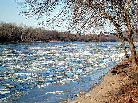
Above: New Hampton Pony Truss Bridge, one of only 2 such structures in New Jersey and one of many National Historic structures and places along the Musky. Thanks to Eric Sween of Bethlehem Twp. (NJ) for the pic.

Last month the Musconetcong River became the most recent addition to the National Wild and Scenic Rivers System (see previous December posts for more details). The Wild and Scenic Rivers Act requires that a river possess "oustanding remarkable" resources of regional, state and national importance.

I worked with a talented group of volunteers over a 2-year period to go about documenting just how the river meets that criteria, and I wrote the "Resource Assessment and Eligibility Report" that lays out in detail the many "oustandingly remarkable" qualities found in and along the river and its immediate corridor.

The amazing historic features found in the watershed proved to be the foundation that the case for wild scenic status was successfully built upon. The following essay is taken from the aforementioned report. In the next post i will discuss the river's outstanding recreational features.

But first I would like to mention that the lower Musconetcong River shares a unique relationship with its sister stream across the Delaware River -- Cooks Creek. The hamlet of Durham was an iron making powerhouse throughout the 18th and 19th centuries, as were the villages along the much larger Musconetcong. This was the iron making hub that supplied Trenton and Philadelphia from pre-revolutinary times through the early industrial revolution.

To download a copy of the Musconetcong River Management Plan click here.

WARNING! This is a long essay, sit back but don't fall asleep!
_____________________________________________________
The Musconetcong Valley: A Cultural Landscape Still In The Making
By John P. Brunner

The Musconetcong River valley is not a place where great battles were fought or important treaties signed. No single historic feature found in the valley is by itself entirely unique to the history of the region, state, or nation.

Yet, few river valleys in New Jersey tell such a compelling story of the interrelationships between humans and the natural environment, none possess so many well-preserved historic features as those found along the Musconetcong River. Outstanding river-related historic features -- many of which are listed on the New Jersey and National Registers of Historic Places -- can be found in Stanhope, Waterloo Village, Asbury, Finesville and several other Musconetcong River communities.

It is easy to overlook just how important the historic places and structures are to the scenic character the Musconetcong valley. As key components of regional tourism, the historic bridges, houses, and villages contribute to the local economy.

Fortunately, the valley's historic and archaeological features have been reasonably well documented. Human habitation in the Musconetcong valley has been traced back to as early as 12,000 years ago when Paleo-Indians occupied the region during the final retreat of the Wisconsin glacier. Evidence of their presence in the valley has been documented at the Plenge Site, which is located along the lower Musconetcong River in Warren County. The Plenge Site was the first of only two major Paleo-Indian archaeological site excavations in New Jersey, and it is considered to be one of the most important in the northeastern United States.

The pre-eminent source of information about human settlement along the Musconetcong River is "The Musconetcong Valley of New Jersey: A Historical Geography" by Peter O. Wacker, Rutgers University Press (1968). Wacker, who is a professor of Geography and Anthropology at Rutgers University, describes how the natural resources of the Musconetcong River valley determined - and were in turn transformed by - human settlement. Rutgers University Press described Wacker's book as "one of the first authoritative studies of its kind."

Wacker gave several reasons for choosing the Musconetcong River valley over any of several others in New Jersey. He stated in his book "A unique opportunity exists in New Jersey, especially in the southern Highlands of the state, to investigate the processes whereby distinct ethnic groups and varied economic interest have transformed the largely forested landscape of aboriginal days to the largely deforested agricultural landscape of today." Wacker was also drawn to the Musconetcong by the documentation of extensive prehistoric settlement, and by the diverse cultural landscapes and economic activities resulting from the occupation of the valley by various northwestern Europeans. He defined the significance of the Musconetcong River in terms of its economically strategic location relative to colonial America's two major commercial centers - New York and Philadelphia.

Perhaps the most compelling reason for making the Musconetcong the locus of his historical geography was an aesthetic one. Wacker wrote, "Despite its proximity to the sprawling ugliness of Megalopolis, the Musconetcong Valley is one of the most beautiful valleys in the Highlands. Much of this character remains in the twentieth century and makes field work all the more pleasant."

Wacker considered both natural and human alterations of the landscape beginning with the ice age 10-12,000 years ago) up to the end of the 19th century. The Paleo-Indians who settled along the Musconetcong lived in a sub-arctic climate that supported forests of spruce, pine, and birch. They hunted elk, caribou, and other mammals no longer found in the region. The river ran full and wide with waters from the melting ice sheets of the Wisconsin Glacier that spilled out into extensive wetlands ringing both sides of the river.

As the climate moderated over a period of several thousand years, the eastern deciduous forest evolved from the ice age boreal forests. With the retreat of the glacier, the Musconetcong River decreased to roughly its current size and, fed by small glacial lakes and mountain streams, it flowed through a sparsely inhabited wilderness to the lower Delaware River.

By the time European settlement came to the Musconetcong valley during the early 18th century, the Leni-Lenape Indians were already in a state of decline, and the several thousand-year-old aboriginal occupation was coming to an end. While the Lenape burned off significant areas of forest to plant crops and attract game, their only lasting imprint on the landscape were the major trails that European colonists eventually converted to roads. One of these was the Malayelick Path, which ran from the head of the tidal Delaware River to the Musconetcong River "gap" between Musconetcong and Schooley's Mountains. The path was the forerunner of State Highway 31, which begins in Trenton and crosses the Musconetcong River at Hampton Borough. Portions of State Highway 206 are part of the Minisink Trail, which linked the New Jersey coast with Minisink Island in the Upper Delaware River (a Lenape settlement was located nearby at what is now Lake Hopatcong.)

From an ecological perspective it is interesting to note that 12,000 years of Native American settlement along the Musconetcong River caused minimal impact on the river and its surrounding landscape. In contrast, a mere 150 years of European settlement profoundly altered the river and surrounding landscape. Wacker's book relates how the parallel growth of agriculture, industry, and transportation rapidly transformed the natural landscape to a cultural landscape.

Subsistence agriculture took root in the lower Musconetcong valley at the beginning of the 18th century. The fertile limestone valley was rapidly cleared for croplands, and subsistence agriculture gradually evolved into commercial grain and dairy farming. Villages sprang up around the many gristmills built along the Musconetcong River from Finesville to Hackettstown.

The charcoal iron industry was also established during the early 18th century on the lower Musconetcong River and eventually it spread all the way up the river valley to Stanhope. Abundant supplies of ore from the surrounding ridges supported iron making. The early iron industry needed charcoal to fuel its furnaces, and since charcoal was made by burning wood, intensive deforestation of the ridges surrounding the Musconetcong valley took place over a period of 100 years.

The iron industry faced a precipitous decline by the early 19th century because wood supplies were rapidly being depleted. However, the industry was rescued when one of early America's truly amazing engineering feats - the Morris Canal - was built to carry coal from the Pennsylvania coalfields to fuel the iron furnaces. The availability of coal all but eliminated the need for wood as fuel, and forests were allowed to regenerate, particularly in those areas too steep, rocky, or wet for cultivations or settlement.

The Morris Canal was a world-famous engineering marvel that required abundant supplies of water. Lake Hopatcong, which was originally a small natural glacial lake, was dammed to supply water to the entire canal system, but it was found to be an inadequate source. To augment the flow of water to the canal, several other dams were built on the Musconetcong River and Lubbers Run, its largest tributary.

Only a few remnants of the Morris Canal remain, yet its impact on the river can be seen in the silted-in dam pools above Waterloo Village and Saxton Falls. The lakes that were created to serve the needs of the canal and iron industry also spawned a new "industry" - summer cottage recreation and tourism. Even as the iron industry and Morris Canal were dying out, passenger trains and automobiles were carrying people to the summer cottages that sprang up along several lakes of the upper Musconetcong River watershed. This historic land-use pattern in the upper valley continues today, although the summer cottages have long since become permanent residences. The lower Musconetcong River valley where agriculture continues to dominate the landscape has undergone remarkably little change in the past 100 years.

The cultural landscape themes contained in Wacker's work help shed light on the current condition of the river and its surrounding landscape, and may even offer a glimpse into the future. Suburban sprawl, the major impetus for the alteration of the natural landscape in late 20th century America, was in its infancy when Wacker wrote A Historical Geography in 1968. One lesson that can be drawn from his book is that the opportunities and limitations presented by natural resources remain constant. People are still attracted to the Musconetcong River valley because of its scenic beauty and abundant natural resources, just as they were thousands of years ago. Soil, water, forests, and wildlife are still vulnerable to degradation and depletion by those who would fail to understand and respect nature's limits.

Tuesday, January 02, 2007

One last time...for 2006


Yes...sometimes I answer the cell while on the water, especially when I know the call is about "what's for dinner?"

Eric hangs under the Stover Mill, one of the most awesome mills on any river in die welt.

Eric S., Wally J. and I convened for an impromptu trip down the Delaware between Frenchtown and Byram last Saturday afternoon, squeezing in one more run for 2006. Never believed we would have so many late-in-the-year opportunties made possible by the balmy weather conditions.

This was a sunny, albeit windy day (headwind of course) and we shared the river with no one, except a few shore fishermen hunkered down by their campfire in front of the Point Pleasant pumping station.

What a beautiful day on the river. This stretch is so beautiful, not that there are any river segments that aren't beautiful, but this stretch is not trash strewn like the P-burg to Riegelsville section. I ended up with a few more miles than expected, but many fewer than planned. Total is somewhere between 400 and 500 miles. Time to go through the river journal and tally.