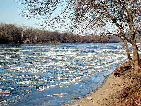
The above pic is from the Delaware River Basin Commission website, no photo credit appears, but I have my suspicions. Thanks DRBC! It was taken February 5, 2007 on the banks of the Delaware at Washington Crossing State Park (NJ side). On February 6 the river was even more choked with ice at New Hope.
I have added a new link to the blog: George and Leona's Delaware River Access Survey. It is found on the National Canoe Safety Patrol - Lower Delaware Chapter website. It is an outstandingly remarkable online resource for river access information, containing many of the major river access points between Hancock, NY and Marcus Hook, PA, which is way down tidal Delaware River. Most accesses include photographs and nifty aerial photos that show detailed road information. It's a work in progress and a project that I hope to assist them with by providing a few photos and editorial comment. Check it out and bookmark it!
..........................................................................................
My canoes have been dry docked in Wally's barn up in the highlands of Holland Township, Hunterdon County. They will stay there until the ice melts, or at least until the air temp gets back above 4o degrees f. I really miss being out on the river, it's such a treasured sanctuary.
As the arctic winds howl and the river clogs with ice there is comfort in the fact that spring is merely a month-and-a-half away. Now is the time for communities along the river and its flood-prone tributaries to begin paying attention to river and reservoir levels, ice buildup and snow pack in the upstream watersheds.
Right now the prognosis looks pretty good as to what impact the '07 spring thaw might have on the river and tributaries. On the other hand, it's really too early to tell. The rosy outlook could wilt with sustained frigid temps, huge ice jams, and a few big snow storms followed by heavy rain and a sudden snow meltdown. Nobody wants another flood scenario like January 1996 (ice jams-rainstorm- big snowpack) nor an April '05 scenario (light snowpack and back-to-back heavy rainstorms).
The prime sources of information to maintain awareness about the river and its tributaries include the Delaware River Basin flood information page and National Weather Service, the later which collects icejam and snowpack data for its "Advanced Hydrologic Prediction Service." And of course there is the Delaware River Journal blog. I keep my finger on the pulse of the river. At all times. It's your one-stop source.
Here is my mid-winter report based on the above resources, as well as several river and creek gages -- and most importantly -- friends who have the good fortune to live in the uppermost reaches of the Delaware Basin -- they see the pristine mountain river and its tributaries everyday. They do the groundtruthing. Thanks!
.................................................................................................
The Delaware River at Riegelsville has fallen two feet over the past week and is running at or slightly below normal. Similar conditions exist for most of the major Delaware River tributaries including the Beaver Kill, and Callicoon Creek in New York, Lackawaxen River, Shohola Creek, Brodhead Creek, Lehigh River and Tohickon Creek in Pennsylvania, and Flatbrook and Musconetcong River in New Jersey. That's the good news.
The bad news is that the three large drinking water reservoirs located in the headwaters of the two Branches of the Delaware River and Neversink River are near capacity (around 95% full) and slightly above the long-term median. The West Branch Delaware River at Hale Eddy was running several hundred cfs higher than normal at the beginning of February, which reflects an ongoing, albeit modest release from Cannonsville Reservoir.
The Delaware River gages at Lordville and Callicoon , NY are literally frozen, the "cfs" simply reads "Ice." This also applies to many other Catskill tributaries to the Delaware River such as the Beaver Kill and Mongaup River. River ice conditions are near or approaching normal and the potential for buildup exists at all the usual places like Narrrowsburg, Port Jervis, Water Gap, and Trenton, to name a few.
The nearly full reservoirs and ice buildup are conditions that need to be watched carefully, but these are offset by the below normal snow pack. There's only a few inches of snow on the ground in the Pocono and Catskill watersheds that drain to the Upper Delaware River and the Lehigh River. If we escape winter without a significant snow storm the river should be well behaved.
For communties along the Delaware River between Easton and Trenton, the weather patterns over the next six weeks, especially in the upriver watersheds, will determine the nature of the 2007 spring thaw.


2 comments:
Nice job John ! Been reading Paddler, Canoe & Kayak and Kayak Touring. Not that it's normal paddling with ice, but many stories are about the northern climates. Paddling with icebergs in Alaska, circumnavigating New Foundland. The stories go on and on. Almost makes you want to go out and bump your boat against some ice...
Yep..I think we have a few more weeks and then the odd 60 deg day in Feb and March will be all that much better.
Post a Comment